This week the National Hurricane Center (NHC) is eyeing a wave by the Eastern Atlantic with a chance for development. It emerged off the Coast of Africa over the weekend and is moving WNW 15 - 20 mph.

On Satellite imagery you can see the area being monitored with deep reds and oranges right next to the African Coast. It now appears the Tropics are waking up. This may signal the start of Cape Verde Season in which waves coming off Africa venture near the islands and then head into the Atlantic with better chances for growth.

This close-up infrared satellite loop shows where you can find the heaviest downpours by the darkest colors. The wave is looking healthier this morning with storms developing with a hint of a spin. NHC will be watching if more thunderstorms develop within the wave, as a sign of organization.
Chances for Development
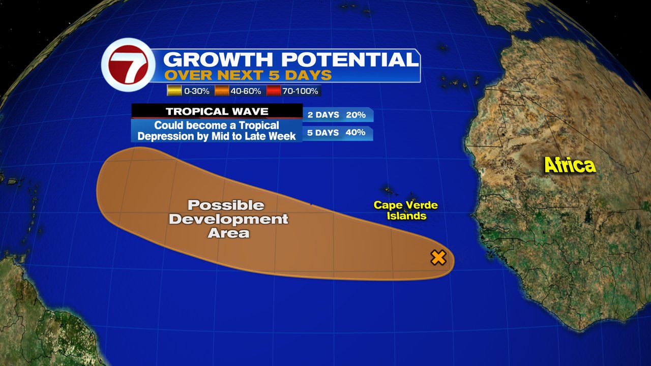
As of Monday morning the wave has a 40% chance for development. It could grow into a depression by the middle to end of this week. If it organizes it will do so in the area highlighted in orange.
Invest 97L
Also NEW, NHC has deemed this wave Invest 97 L. "Invest" for an area they would like to "INVEST"-igate further, "97" is a tracking number, and "L" is for the Atlantic Basin. This allows them to initiate some very early model runs.

Keep in mind these are guesstimates since nothing has formed. Strong Upper Winds (Shear) which could keep the system from organizing, are barely present. There's still some Saharan Dust to contend with, and Sea Surface temps are not that warm there. A NOAA High altitude mission has been scheduled for Tuesday.
Models
European

This run does not know what to make of Invest 97 L and keeps it out in the East/Central Atlantic. It suggests a very strong dome of high pressure to the north will keep the wave stuck in the region with a slow drift westward. Will have to wait and see what later runs suggest.
GFS

This is a more aggressive outlook with a possible depression/storm developing and moving north of the Leeward Islands.
This feature is very far away from any land areas and we'll have plenty of time to watch. We are now going into the most active part of the season as we progress thru the rest of August and September. Its a good reminder to make sure you are ready in case Mother Nature throws us a curveball.
A Quiet Streak

South Florida is experiencing rather tranquil conditions with the last system reported over a month ago.
We'll be Watching


