Tuesday, May 31, 2022

Weekend Tropical Rain?

As of Tuesday morning, the National Hurricane Center (NHC), says Agatha has weakened into a depression over Mexico. Now it's our turn to keep an eye on whatever is left of the system.


The mass of clouds moving towards the Yucatan Peninsula is Agatha. Not well organized with weaker winds, but still plenty of rain. You will notice a streak of clouds moving west to east just to Agatha's north... this is a strong river of wind known as the Subtropical Jet Stream. It will be the main driver in pushing Agatha's remnants our way. It could also prevent it from restrengthening.  This is something we will track carefully. 


The morning advisory & cone suggests that by this afternoon or early evening, the system will have fallen apart.

What Next?


NHC suggests that Agatha's leftovers may reorganize in the area highlighted in orange. They give this possibility a 60% chance. Even if it doesn't develop, a broad area of low pressure is forecast to form and spread all of Agatha's moisture towards Cuba, So. FL and the NW Bahamas.

Model Comparison


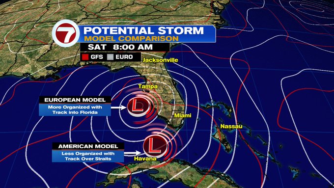
Both the EURO & GFS, place a low near Florida by Saturday. The EURO puts it by SW Florida and the GFS in the Straits. While the EURO puts it away from South Florida it would be the wettest scenario for us. The GFS could cause strong downpours by the Keys and some on & off rain for the Mainland. The NW Bahamas will see some heavy rain either way.


Weather or Not?


Today we launch season 2 of our science and weather podcast, just in time for hurricane season which begins on Wednesday. In this week's episode, we hear from NOAA regarding how active 2022 may be. We talk to a hurricane specialist about all the work that goes on behind the scenes to bring you advisories and cones of concern. Plus a look back at 2021.  You can find us on Spotify, Apple, or Google. Please check us out. Specially if you love science!! 


Sunday, May 29, 2022

Nearby Tropical Action?

A powerful hurricane is battering Southern Mexico at this hour. It will continue towards the coast through Monday afternoon. That's when it's expected to make landfall, with a strong storm surge, heavy rain and intense winds. It may be a major hurricane, category three, by then.


The satellite imagery shows Hurricane "Agatha". A well organized system moving onshore. It has been intensifying rather quickly and is forecast to get even stronger overnight.  The hurricane is moving very slowly northward and will continue to feed off the warm waters. 

Advisory & Cone


The forecast cone from the National Hurricane Center shows a possible landfall Monday afternoon, then inland by Tuesday.

Why the Northeast Track?


This surface map from the Mexican Meteorological Office shows a blue arrow pointing East across Northern Mexico and into Louisiana. That is part of the jet stream, or a strong river of wind in the atmosphere.

Typically, systems that develop in the Pacific Ocean tend to move West/northwest. In this particular case, Agatha is being pushed northeastward due to the subtropical branch of the jet stream.

Looking Ahead

The National Hurricane Center (NHC), suggests that the Mexican High terrain should dissipate Agatha in roughly 36 hours. It should still be over land.  But, if the remnants survive into the Gulf of Mexico, the warm waters there could brew something back up.


NHC says that whatever is left of Agatha, may get its act together once again. If it does so, it is forecast to take place in the area highlighted. At the moment, there's a 30% chance of this scenario happening. This will be just in time for the start of hurricane season which happens on June 1st.  A good reminder to stay with us here, on-line, and on-air for the latest tropical updates.


Tuesday, May 24, 2022

2022 Hurricane Season Forecast

The National Oceanographic and Atmospheric Administration (NOAA) released its official 2022 hurricane season outlook. The projections call for an above average season.


They are calling for 14 to 21 named systems, out of which 6 to 10 may become hurricanes, and out of that number 3 to 6 could reach major status. Those are hurricane with wind speeds over 111 mph. If you see what the the average numbers are, it looks like 2022 will be an active one.


NOAA says there are several factors for this forecast:

 1) The ongoing La NiƱa that is likely to persist throughout the hurricane season 

2) Warmer-than-average sea surface temperatures in the Atlantic Ocean and Caribbean Sea 

3) Weaker tropical Atlantic trade winds and an enhanced west African monsoon. An enhanced west African monsoon supports stronger African Easterly Waves, which seed many of the strongest and longest lived hurricanes during most seasons. The way in which climate change impacts the strength and frequency of tropical cyclones is a continuous area of study for NOAA scientists.

A reminder:

None of these forecasts will ever tell us when and where a system will make landfall. It only takes one. We will be here keeping you updated of any storm headed in our direction.

Hurricane season begins June 1st and runs through the end of November. The entire 7Weather team is dedicated to keeping you safe. There are many ways you can reach us. 

  • Download the 7Weather or the 7Hurricane tracker apps
  • Hurricane Hotline phone numbers. Active when a storm is being tracked. Miami-Dade 305-477-7751 Broward 954-776-7751
  • On Line at 7Weather and of course through this blog.

Hoping that no storm threatens us this year.


Sunday, May 22, 2022

Fist Invest of 2022

The National Hurricane Center (NHC) is monitoring an area of disturbed weather in the Gulf of Mexico for possible development.


In the satellite view, you can almost see the center of the pinwheel just SW of Pensacola.  NHC is giving it a low 10% chance for organization over the next 5 days. 


As of Sunday evening, if the disturbance develops, it will do so over the area highlighted yellow. 

Location

COURTESY TROPICAL TIDBITS

This elongated area of low pressure should move onshore as early as Monday morning. Even without organization, it is capable of heavy rain from Coastal Louisiana to the Panhandle of Florida.

Forecast

NHC has deemed this disturbance Invest90L. Invest for an area they would like to INVEST-igate further, 90 is a tracking number and "L" is for Atlantic Basin.   This is the first invest of the season which starts June first.


This is just a reminder, hurricane season is just around the corner. This is the time to review your plans when all is quiet in order to be ready when and if an actual threat takes place.


Subtropical Storm Nicole

We begin the work week with the prospect of a tropical system impacting the East Coast of Florida this week. This is Subtropical Storm Nicol...