Monday, November 7, 2022

Subtropical Storm Nicole

We begin the work week with the prospect of a tropical system impacting the East Coast of Florida this week. This is Subtropical Storm Nicole.


Dr. Phil Klotzbach from the University of Colorado says Nicole is the third named system in the Atlantic Basin since Halloween. The two others were Lisa and Martin. This is a record, the most activity post October 31st thru November 7th.

What is a Subtropical storm?


It's a system that has most of its rain and winds away from the center of circulation. At times over 100 miles away. They can at any moment become the typical tropical system with a warm core and all the strongest winds and rain around the center or eye.

Where is it Headed?


The center of Nicole formed early Monday morning. Now that there's a good center spin, the models can gives us a better forecast. 

  • High pressure to the NE will push it towards the NW Bahamas and then the East Coast of Florida. 
  • It may approach as a category 1 system with winds around 75 mph sometime late Wednesday or early Thursday morning. 
  • It will then cut across the peninsula, stopped by a front and pushed back into the state. Just about all of Florida may be impacted by the storm.


Models


The GFS puts Nicole across South Florida by November 10th. Notice the high pressure system steering Nicole towards Florida in the short term.


The Euro model places Nicole possible along Palm Beach County. BUT A REMINDER, this is just where the center or the eye of the hurricane would be. Impacts from a system can be felt many miles away from the center. In this case the high weakens just a tad permitting a slightly northward jog by Nicole.

Impacts for NW, Central Bahamas & Florida
Nicole may end up being a large storm in size. This will allow it to impact plenty of folks way beyond the landfall area. Here's what to expect:
  1. At least Tropical Storm Force winds (39 mph and above) 
  2. Its forecast to be a hurricane as it near the NW Bahamas 
  3. Torrential downpours, Rough surf, rip currents and coastal flooding. 
  4. King Tides this week could make the coastal flooding problem worse.

Graphical Impacts


The local @NWSMiami office is offering their assessment of possible impacts for the area. Here's a good look as to what areas by be impacted by wind, rain, surge, or tornadoes. These will probably change as the system nears So FL.

Even though we are getting to the end of hurricane season, Mother Nature will decide when she is done with the tropics. 


We'll keep watching


Friday, October 7, 2022

Hurricane impact on Nicaragua?

The National Hurricane Center is forecasting a category one hurricane to impact Central America, specifically Nicaragua. This is due to recently upgraded Tropical Storm Julia. It had been impacting the Coast of South America as Depression 13. 


The storm is basically moving over the Guajira Peninsula, and is still being nagged by land interaction.  Julia is the fifth tropical system to actually cross the Guajira Peninsula, which is part of both Colombia & Venezuela. The last time this happened we need to go back to 1996 with TS Cesar. 

This brush with the South American Coast kept TD 13 in check fbut now it has begun intensification. More clouds are developing along the center spin with additional storms popping up.  

What Next?


The forecast cone suggests that High Pressure's influence from the Atlantic Ocean into the Gulf of Mexico, will push the storm west. 

As it moves away from land it will have a chance to become a hurricane before landfall. 

Headlines

  • Through the morning and early afternoon, gusty winds to tropical storm force (over 39 mph) will be possible across the Guajira Peninsula, parts of Venezuela, and Aruba 
  • Torrential downpours will lead to flooding, land and mudslides in the areas named above, as well as Aruba, Bonaire and Curacao
  • The system is forecast to make landfall by Nicaragua late in the weekend. They along with Honduras should be getting ready for a possible strike 
Rain Forecasts


This will be the biggest impact in parts of Central America and Mexico.  Some spots in interior Nicaragua could see up to 15 inches.

If you have family and friends in Nicaragua and Honduras, please contact them and tell them what is forecast so they can prepare accordingly.

We'll be watching


Thursday, October 6, 2022

New System to Watch in the Tropics

As of 11 am Thursday, The National Hurricane Center (NHC),  is tracking Potential Storm 13. This is not a fully organized storm but has the potential to be one shortly. By issuing advisories now, it allows countries in its path to prepare accordingly.


Right Now

It's basically a broad area of low pressure with huge amounts of rain.  The alleged center of circulation is too close to land and thus its spin is somewhat interrupted. This is not allowing it to fully develop.  Winds from the system are picking up to near tropical storm strength and therefore NHC has initiated advisories. 

NHC is having a hard time trying to identify exactly where the center is located.  As of Thursday morning it is being placed just north of Coastal Venezuela.  Being so close to land will keep its intensity in check for a good 24 hours.

Next

High pressure in the Western Atlantic will steer the system west brushing up along Venezuela, Aruba, Bonaire, Curacao (ABC islands), and Colombia. It may become Tropical Storm Julia by Thursday evening or Friday morning. 

Over the weekend, the system may get stronger as it will travel impeded over warm waters. This will give it a chance to possibly become a hurricane just before moving onshore across Nicaragua, Belize, Honduras, or Yucatan. 

Important Notes

  • Winds over 39 mph are possible along Colombia's coast Thursday night to Friday morning. A Tropical Storm Warning is in place there.  Northern Venezuela, and the ABC Islands, will also experience tropical storm force winds of over 39 mph. 
  • Heavy rainfall will make a huge impact leading to possible flash flooding in many areas along the system's path specially along portions of Central America. More watches and warnings may be issued over the next 24 hours.
  • Rain may be felt along Jamaica and Grand Cayman as well.

NO impacts for the Bahamas or Florida.

We'll be watching


Monday, September 26, 2022

Hurricane Ian & Florida

 The National Hurricane Center (NHC) upgraded Ian to Hurricane Status early Monday morning.


Overnight Ian intensified and continues to get better and better organized. It is soaking up all the heat energy of the Caribbean waters to grow stronger. The satellite loop shows a more symmetrical system with a better looking eye.

The center of the storm has come together now that shear has relaxed. Ian has a better looking core allowing it to draw up additional moisture for thunderstorm formation.  Imagine the center being a straw standing upright.  Nothing is squeezing the straw or preventing it from soaking up the steam coning off the water.

Also, if you look at the satellite loop, you can see the counterclockwise spin of the hurricane. There are also some clouds moving in the opposite direction. This is called outflow and it's taking place in the very high cloud tops. Basically this is Ian's exhaust pipe. Hot, moist air goes in at the surface and then its spun out as cooler air after it has rendered all its fuel. When this mechanism is happening, it's a tell tale sign that we have a very powerful hurricane in the makings.

What Next?


  • Hurricane Ian is forecast to become a major hurricane just before impacting Western Cuba.  This is a mostly rural area of the island. Still, it will cause plenty of rain that will lead to flooding dangers. Winds will cause damage as it it tears its way into the Gulf.
  • Forecasts indicate Ian, will thankfully move rapidly over Cuba. Hopefully this will keep the impacts down some.
  • Once in the hot waters of the Gulf of Mexico , additional strengthening is anticipated.
  • The west coast of Florida should be prepared for what could be a major impact from a major storm.

Possible Impacts

These are projections from NHC

Storm Surge:

  • E Cape Sable to Card Sound Bridge & FL Bay 2-4 ft 
  • Florida Keys including the Dry Tortugas... 2-4 ft

Wind:

  • Trop storm conditions expected in the warning area in lower Florida Keys on Tuesday. 
  • Trop storm conditions are possible in watch area along the Florida west coast by Tuesday evening. 
  • Hurricane conditions are possible along the Florida West coast within the Hurricane Watch area on Wed, with tropical storm conditions possibly beginning by Tuesday night.

Rain totals thru Thursday:
  • Cayman Islands: 3 - 6 up to 8 inches in spots.
  • Western Cuba: 6 to 10, up to 16 inches.
  • Florida Keys: 4 to 6 inches.
  • Central West Florida: 8 to 10 up to 15 inches.
  • Remainder of the Florida Peninsula: 3 to 8 inches.
Ocean Swells:
  • Swells are expected to begin affecting the Florida Keys Tuesday and spread northward along the west coast of Florida through Wednesday. These swells are likely to cause life-threatening surf and rip current conditions.

Watches & Warnings:
A Tropical Storm Warning is in effect for...
* Cuban provinces of La Habana, Mayabeque, and Matanzas
* Lower Florida Keys from Seven Mile Bridge westward to Key    West
* Dry Tortugas

A Storm Surge Watch is in effect for...
* Florida Keys from the Card Sound Bridge westward to Key    West
* Dry Tortugas
* Florida Bay
* Anclote River southward to the Card Sound Bridge
* Tampa Bay

A Hurricane Watch is in effect for...
* Englewood to the Anclote River, including Tampa Baykmh

South Florida Forecast:

With so much moisture being swung in our direction, moments of very heavy rain will move in from time to time across our area thru Wednesday. The wind may also pick up within these rain bands.  Marine conditions will also degenerate as the systems passes by to our West.

Please tune in from time to time at WSVN on-air and on-line for the latest. New advisories are issued every three hours now, at 2, 5, 8,  & 11 throughout the day.  While most models keep the center or eye, of the hurricane in the Gulf, its impacts will be felt miles away.

We'll be watching

Saturday, September 24, 2022

Ian on the move & shifting west

 Tropical Storm Ian is churning through the Caribbean


Tropical Storm Ian is still not looking good on satellite imagery but models insist on it getting stronger as it moves over warm waters.

Most of the clouds and rain remain on the western side of the storm with mostly cloud free conditions on the eastern side.

A NOAA high altitude recon plane detected that the center is tilted. Imagine a tube from an empty roll of paper towels standing upright.  A healthy system would have the center standing straight but in this case it's tilted. This is from Ian still battling shear or very strong upper winds.  As long as the shear is there it will keep the system from intensifying, but once it's gone, Ian will rapidly gain strength.

Where is it going?


For the moment it's moving more SW but eventually it will turn NW moving along the western periphery of High Pressure to the East. This SW jog will delay its turn north. This moved the entire cone west, with more of a Gulf of Mexico trek.


The close up cone places Ian as a category 3 in the Gulf with a possible track towards west Florida.  Most of the Broward / Miami-Dade county Metro areas are out of the cone. This cone may shift over the next day or two depending on what land interaction impacts may do to Ian.  IF the cone does not change So FL may get some gusty winds and heavy rain. The rain could lead to street flooding.

A reminder the cone shows you where the center of the storm may be at the forecasted time. Keep monitoring.

Impacts

  • Jamaica & Cuba: Heavy rain fall will lead to flash flooding, land, and mudslides. Hurricane conditions expected by Sunday
  • Cayman Islands:Hurricane force winds with heavy rain expected by Monday
  • Florida Keys: Street flooding will be possible by early next week 
  • Western Cuba: Ian nears as a possible major hurricane. Hurricane Force winds, heavy rain, and flooding are forecast. 
  • Florida: Should watch and prepare as the forecast come aims for the state. 
  • Mainland South Florida: While not in the cone, impacts will be possible such as heavy rain, gusty winds, and some flooding.

This info is from the Miami NWS office:

To open the long term period, all eyes turn to the tropics as newly
designated Tropical Storm Ian churns in the central Caribbean Sea.

There is still a lot of uncertainty regarding timing and impacts for
South Florida, but regardless expect an increase in rainfall and
potential wind impacts as early as Monday night and potentially
lasting through Wednesday. Stay tuned over the coming days as
forecast details become more focused, but take this weekend to
review your hurricane plan and make sure you are prepared for any
potential impacts.

We hope that Ian is kind throughout the Caribbean and to others down the road. Please stay informed of the latest. Tropical systems never travel in a straight line and can jog in many directions. 


We'll keep watching


Friday, September 23, 2022

So. FL. is in the Cone

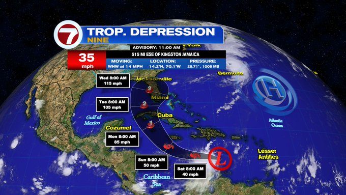
 As of 5 am Friday morning, The National Hurricane Center (NHC) elevated the status of an area of low pressure in the Caribbean Sea to Tropical Depression Nine. The forecast track places South Florida in the Cone of Concern.


Tropical Depression Nine may soon be elevated to Tropical Storm Hermine (pronounced Her-MEEN). NHC places the system somewhere inside the shaded area. The center could be anywhere in the cone of concern, as far East as the NW Bahamas and as far West as the Gulf of Mexico. It may be as strong as a Category two or winds greater than 96 mph. By the time it reaches the west coast , it could be as strong as a category three. This would make it a major storm.

Satellite View


The center of the system is just North of Venezuela and Colombia. Clouds and storms have increased on the western side. As of Friday morning it had a good surface spin or circulation that had been visible since the day before. Most of the rain is impacting Northern Colombia.

The depression is not completely firing on all cylinders. Notice the small spin in the middle of the loop, that is the center of the system. Most of the clouds and rain are on the western side. When clouds and rain wrap around the center completely, then a healthy stronger system will be present.

What Next?


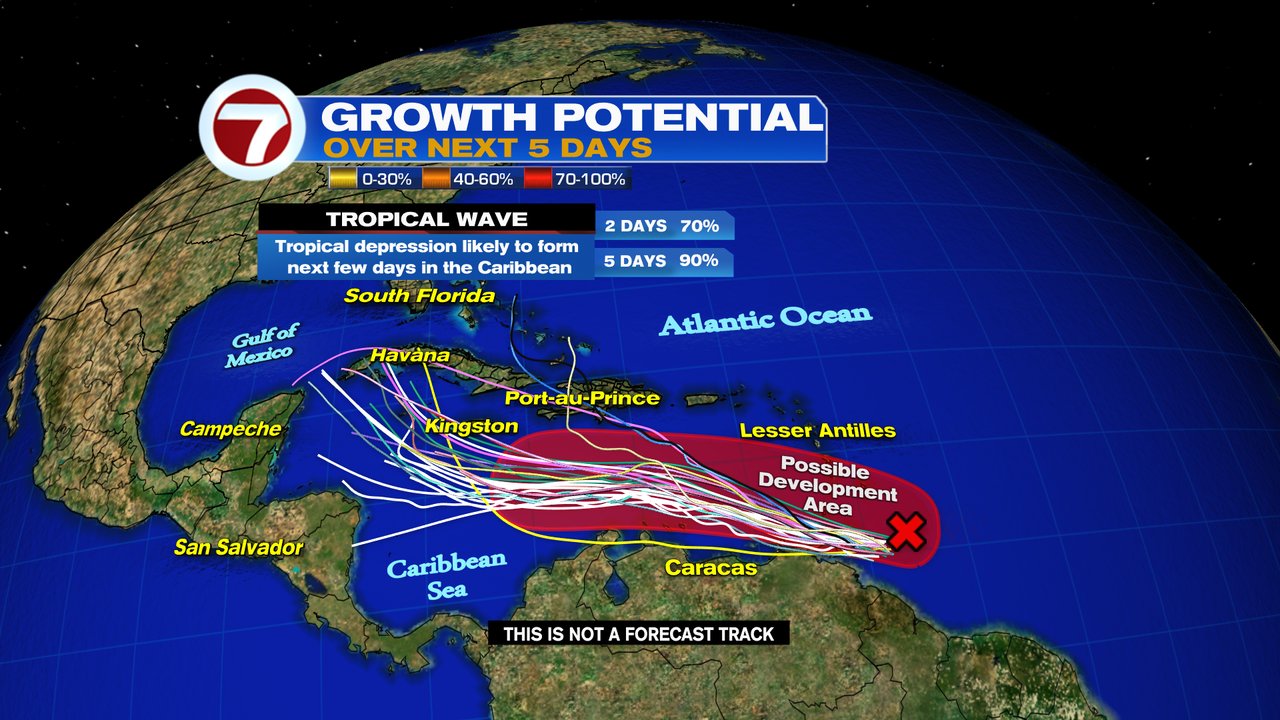
The models are coming into agreement more and more. On Thursday the spread was much wider with a few taking it into the Yucatan Peninsula, others into the northern Gulf of Mexico, and some into South Florida. The latests, suggest a NE turn into the Sunshine state. Where exactly it will make landfall is still not certain.

The thinking is that the system will run into either a stalling front or high pressure coming off the U.S. Mainland. This, in turn will force the system East.  Ultimately it will be a matter of timing. How fast will the depression move into the Gulf and how quickly the high and the front make it to the southeastern U.S.

Cone


High pressure in the Atlantic will push Depression 9, NW over warm waters with little atmospheric interference. This will give it a chance to intensify. A reminder that while track forecasting is very good, intensity forecasting is still not 100% accurate. This depression is forecast to become a Hurricane by Western Cuba. It could be stronger or weaker as it passes over the region so remain alert.

Things to Watch for:

  • The system will produce heavy rain in Aruba, Bonaire, & Curacao. 
  • Venezuela may see 2 - 5 inches of rain
  • Colombia: 3 - 6 inches will be possible
  • Downpours will later move into Jamaica and the Cayman Islands. Rainfall forecasts call for 4 - 8 with 12 inches in spots. Watches and warnings may be issued for you later today 
  • Southern Dominican Republic & Haiti: 2 - 4 inches with some areas as much as 6.
  • By early next week it should be over Western Cuba and near Florida.

This kind of heavy persistent rain can lead to flooding , land , and mudslides. 

Presently


From NWS Miami Weather Office
Based on current model solutions, impacts
could range anywhere from increased moisture and thunderstorm chances
to hurricane conditions over South Florida. Given the widely ranging
model scenarios, it is impossible to say exactly what impacts this
system will have on local South Florida weather at the moment. With
favorable conditions ahead, it appears likely this system will be
strengthening this weekend and heading towards the Gulf early next
week. More details regarding track and intensity of this system will
be better understood in the coming days as models get a better handle
on the storm. In the meantime, it is a great idea to make sure your
hurricane plan is mapped out and you are keeping up with the latest
forecasts from official sources.

It is practical for all of us in the cone to review our hurricane plans and supplies. Remember your pets and medications. Many things can change with this system. The atmosphere is in constant flux so the path and intensity may change. Sometimes for the better and sometimes for the worse. It's important to stay informed. You can always get the latest on-air and on-line at wsvn as well as on Twitter, Facebook, and Instagram. 

Caribbean Impacts

Jamaica: Has already issued an advisory this morning. All the details can be found on this link: Jamaica - Advisory

Cayman Islands issued this statement: The Cayman Islands National Weather Service will continue to monitor the progress of this Depression. The public is advised to keep abreast on the progress of Tropical Depression 9.

Cuba: Presently advising the resident on the Western Side if the island to remain vigilant.

We'll be watching

Wednesday, September 21, 2022

Following Five

The National Hurricane Center (NHC) is tracking or following Five areas in the Atlantic Basin. From powerful Hurricane Fiona, Tropical Storm Gaston, to three waves. One of which should be watched closely across the Caribbean.


  • A tropical storm warning and hurricane watch is in place for Bermuda. They may have to deal with the system by the end of the week. 
  • Gaston would remain a worry only for the shipping lanes 
  • Of the three waves in the tropics, one is worthy of monitoring closely

The Caribbean, Yucatan Peninsula, Gulf of Mexico, and Florida should watch a wave that may develop over the next few days.


The image above shows powerful Hurricane Fiona moving away from the Turks & Caicos. The unimpressive cloudiness by Venezuela is the tropical wave being watched. It doesn't look like much at the moment as shear or strong upper winds are keeping it from organizing. But NHC is giving it a 90% chance as of Wednesday morning for development.

Location: 10.2°N 59.0°W 
Maximum Winds: 35 mph
Minimum Central Pressure: 1009 mb 
 

Where may it organize?


It may become a depression or a storm somewhere in the red shaded area over the next 5 days. Notice the models are indicating it could end up anywhere across the Caribbean through the weekend. All keep it away from Puerto Rico, Dominican Republic, and Leeward Islands. They were just struck by Fiona and do not need a repeat of that.

Impacts

From Trinidad and Tobago Weather Office

  • Showers and isolated thunderstorms, at times heavy, are expected from Wednesday morning over oceanic waters and extending across Trinidad and Tobago. This activity is associated with an active tropical wave with potential for development over the next few days. 
  • Gusty winds in excess of 70km/hr can be expected along with rainfall accumulations of 75 – 125 mm. Street or flash flooding are likely in areas of heavy downpours. 
  • Impacts can include larger than normal waves in both open waters and in the Gulf of Paria. Tree branches and loose objects can be displaced during strong winds. Traffic disruptions are likely in flooded areas. Expect periods of lull between bursts of rainfall and thunderstorm activity.

From Jamaica Weather Office

Most guidance suggests that the disturbed weather approaching the Caribbean with potential for development will remain a strong tropical wave or tropical storm passing just south of Jamaica. It is, however, likely to become a threat so continue to monitor closely

From Cayman Islands

Monitoring 98L following advisory from @NHC_Atlantic Disturbance forecast to move W-NW through Caribbean Sea later this week. Residents urged to monitor development of this system.

Venezuela

Along the Coast, the possibility is there of some gusty winds and rain. That will increase as the wave moves further west.

How strong could it be?

Courtesy Tropical Tidbits.com

Strength of a system is very difficult to forecast since there are so many variables. The graph above shows a handful of models trying to do just that. It appears that here too there is a wide spread since we really don't know the track yet. But the spread takes it as strong as a major hurricane in about 5-7 days.

For South Florida. No worries at the moment, but keep your eyes on it. Any system forecast to be near our area deserves to be watched.

We'll be watching


Subtropical Storm Nicole

We begin the work week with the prospect of a tropical system impacting the East Coast of Florida this week. This is Subtropical Storm Nicol...