Tuesday, June 28, 2022

Watching thee areas

It's very crowded in the Tropics this Tuesday with two disturbances being followed for possible development and one potential storm.


To the right of the image above, we see Africa with yet another wave coming off the Coast. In the center of the picture we find what MAY become Tropical Storm Bonnie, and way up in the upper left hand corner is a small disturbance poised to dump plenty of rain across Texas.

Potential Storm #2


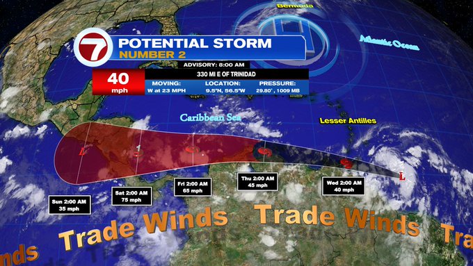
As of Tuesday morning, this system was moving west rather quickly.  This is keeping it from forming a well closed center of circulation and even further thunderstorms.


Sunrise over the Central Atlantic shows some bubbling cloud tops correlating with thunderstorm activity. It will be interesting if the system can overcome many hurdles today. For the moment, the low level spin is moving faster than the higher part of the system. This will keep it struggling for awhile. 

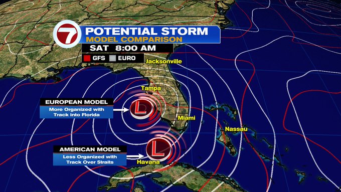
There's also the forecast track. Will the center stay over water and gather more energy from the warm waters or will it move onshore Venezuela and get cut off from its fuel source.

Where is it going?
The forecast cone shown previously, keeps the center hugging the South American Coastline. Even if it doesn't become Bonnie right away, it will dump plenty of rain across the region. From Trinidad & Tobago, over Venezuela & Colombia.  

Eventually, the models do take up to hurricane status just before moving onshore Central America. They suggest warmer waters and low shear in the SW Caribbean Sea could intensify the system.
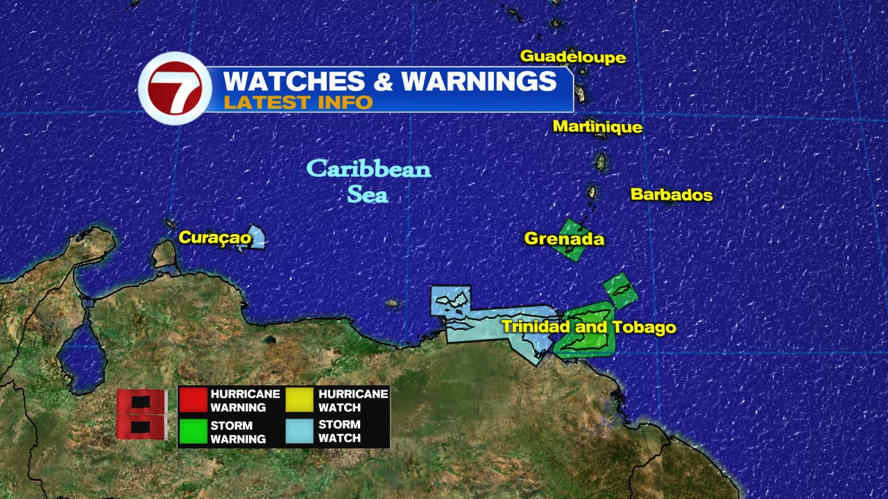
Impacts (From NHC)

RAINFALL: The Potential Tropical Cyclone is expected to 
produce heavy rain across the southern Windward Islands 
and the northeastern coast of Venezuela starting tonight 
into Wednesday.  The following storm total rainfall amounts 
are expected:

Islands from Guadeloupe to St. Lucia: 1 to 3 inches.

St. Vincent, the Grenadines, and Barbados: 3 to 5 inches.

Grenada, Trinidad and Tobago, and northeastern Venezuela: 
4 to 6 inches.

WIND:  Tropical storm conditions are expected in the warning 
area in the southern Windward Islands tonight. Tropical 
storm  conditions are possible in the watch area along the 
northeastern coast of Venezuela

Watches and Warnings

The following areas are under Tropical Storm Watches and Warnings

What is a Potential Storm?

This is a designation NHC uses to allow watches and warnings to be issued, before the low can become an actual Tropical Storm. It gives folks in its path more time to get ready instead of waiting until the storm is on them to do so.

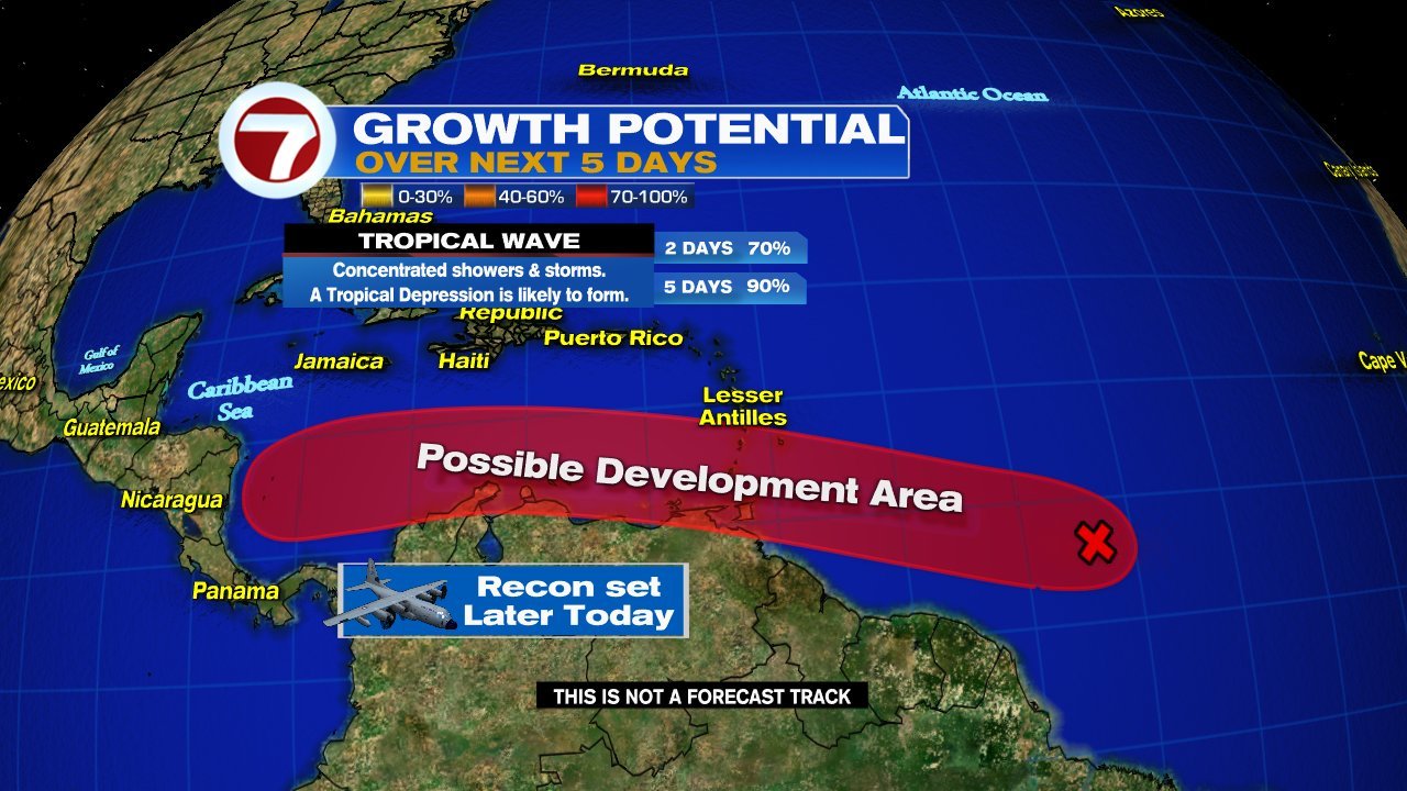
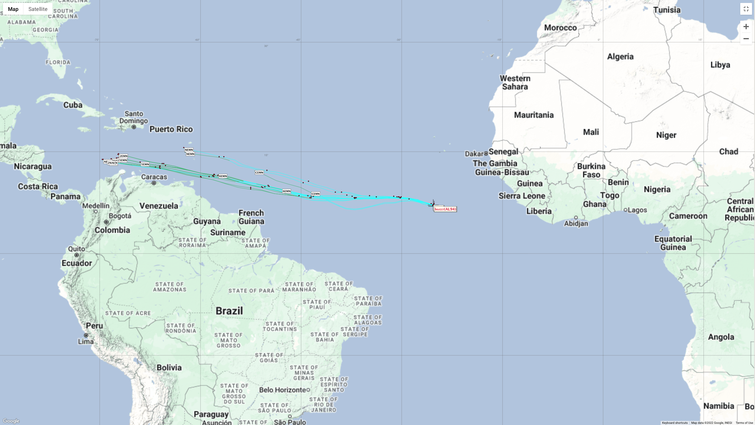
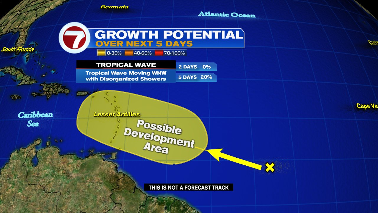
Two other areas being watched 

NHC is monitoring a wave behind Potential Storm #2 with a 20% chance for organization in highlighted area, while another feature is being monitored in the Gulf  with a 30% chance for growth. Both are capable of heavy rain.

In the Atlantic


In the Gulf of Mexico


We'll be watching 

Sunday, June 26, 2022

Tropical Activity in the Gulf & Atlantic Ocean

 UPDATED: The new week starts with the National Hurricane Center (NHC) monitoring two areas for development in the Central Tropical Atlantic and a third in the Gulf of Mexico.


We start with the first Atlantic Wave

This satellite view shows imagery over the Atlantic.  The area of clouds we are focusing on is roughly 900 miles E/SE of the Windward Islands. A NOAA high altitude recon mission is set for today with hurricane hunters on standby for Tuesday. 

The wave maintained its form over the weekend without getting stronger,  but now conditions appear more favorable for further development.  It's moving West 15 - 20 mph. 


NHC is giving this wave a 90% chance that it could become a depression/storm anywhere inside the red highlight over a period of 5 days. If it reaches tropical storm status it will be named "Bonnie". Even without organization it could drop plenty of rain across the Windward Islands, Trinidad & Tobago, as well as Northern Venezuela. Advisories could be issued for them as early as today.

Second area of concern in Atlantic

This is another wave just behind the first. It is moving WNW at 15 mph. This one could be more of a headache as it appears to be tracking farther north than the previous. 


NHC suggests it has a 20% chance for organization inside the yellow area over a 5 day period.  The Lesser Antilles could see pockets of heavy rain in the days ahead.

Activity in the Gulf


The area of clouds sitting mostly over Louisiana, Mississippi, & Alabama is a disturbance that has a low chance for intensification. 

NHC says it will drift west and possibly organize by the Texas Coastline. They give this possibility a 20% chance over 5 days.  Even if it doesn't come together it will be capable of heavy rain.


We'll be watching


Watching Two

Two areas of concern being monitored by the National Hurricane Center for possible development this Sunday. One has a high chance for turning into a depression, the other a low probability.


Area of Concern #1

We begin with the highest chance. This is a Tropical Wave in the middle of the Atlantic Ocean somewhat near the Equator. A small spin is detectable along with plenty of rain and thunderstorms.  

Where is it Headed?

It is possible that it could become a depression early to mid next week. It can organize anywhere in the area highlighted red. This wave, also known as Invest94L, will first arrive over the Windward Islands,  Trinidad & Tobago, as well as Northern Venezuela. Heavy rain and gusty winds are possible Tuesday thru Wednesday. Once it departs. it should stay in the Southern Caribbean Sea. Still needs to be monitored.

Area of Concern #2


A big area of Clouds and Rain stretches along the Gulf Coast from Louisiana to the Panhandle.  This is an elongated area of low pressure. If it organizes, it will do so in yellow circle. as seen in upper map.  NHC gives it a low chance for growth.  

No concerns for South Florida as of this moment. 


Friday, June 24, 2022

Caribbean Concern

The National Hurricane Center (NHC)  raises chances for a wave to develop in the Atlantic Ocean over the next five days. Late Thursday night it was deemed Invest94L.


On Satellite View, you can see the sun rising over the West Coast of Africa, seen in the upper right.  It shows a vigorous disturbance moving into the left side of the image, SW of the Cape Verde Islands. Notice there is yet another cluster of clouds and rain that has just moved offshore as well. It is moving west between 10 - 15 mph.

The Latest from NHC


Data from Friday morning, suggests the Tropical Wave has a 60% chance (up from 20% Thursday morning), of becoming a depression somewhere in the orange area during the next 5 days. Waters are running warm and that could supply the energy it needs to grow.

Models


The early runs from NHC suggest a westward track staying well south possibly heading towards the Windward Islands or even skirting the North Coast of Venezuela.


Another look at several more models of Invest94L. A reminder that since nothing has developed, the models have no starting point, so at the moment,  they are just providing a general view of the possible track.  

Each line represents where the center of the storm may be at any given time in the graph.  Some models are statistical while others show a track if nothing were to change. 

For example take the black triangled line above. This is the Extrapolation model. It says, if the system has been moving NW over the last 12 hours, it will continue to move NW.  As you know, there are so many variables in forecasting that a track could change within hours. Deviations in a forecast can come at any time.

Why the Bullish Forecast?

Three major factors are in play.

  1. The wave has plenty of moisture allowing it to form more thunderstorms.  
  2. It'll be moving over warm waters. 
  3. Little to no roadblocks in the way of Shear, or strong upper winds that can keep it from organizing


This lack of shear will remain in place by the time it reaches the Windward Islands. Folks there should keep an eye on it. Even if it doesn't organize it should still drop plenty of rain. If this system were to be named it would be called Bonnie.

The rest of the Caribbean, the Bahamas and South Florida, just keep monitoring it. This is a good reminder to check your supplies.  We'll be watching.


Friday, June 3, 2022

Tropical Soaking

A "Will Be" storm is pushing clouds, rain, & winds in our direction.  It remains Potential Storm #1 until Friday afternoon when it should reach full tropical storm status and carry the name "Alex", the first of the 2022 Atlantic season.


If you look closely over Yucatan, you can see faint low level clouds moving counter clockwise. This is the western side of the system. For the moment all the rain and wind is on the eastern side.

The National Hurricane Center says this system is being impacted by strong upper winds limiting its growth potential. Regardless, it should have enough energy to become a tropical storm later today.


As of the 8 am advisory, the watches for So. FL the NW Bahamas, and Western Cuba are now elevated to Tropical Storm Warnings. 


This means that winds of 39 mph and higher can be expected at times across the area during the next 24 hrs. Please try and secure whatever loose objects there may be in your property as a safety measure. 

CONE


While the cone of concern does not include Southeast Florida, the system itself is rather large and its rain and wind will be felt far outside the cone.

IMPACTS

The main concern will be the copious amounts of rain Cuba, South Florida and the NW Bahamas may see. Models are calling for 4 - 8 inches with a few going as high as one foot. This will surely lead to flooding of low lying areas. A Flood Watch is in place for South Florida thru Sunday morning. 

WE MAY EVEN SEE SPOTS WITH FLASH FLOODING.

It appears the worst stretch for the region should be between this evening and Saturday with the NW. Bahamas mostly on Saturday.

We'll be watching


Thursday, June 2, 2022

Recon set for Today

 The National Hurricane Center (NHC),  is keeping a close eye on a broad area of low pressure spinning off the Yucatan Peninsula on Thursday morning.


The big area of clouds entering Western Cuba continues to cause plenty of tropical downpours, but as of this update, it has not organized.  The Northern extent of the cloud mass is being impacted by strong upper level winds zooming West to East and keeping the low in check.  NHC thinks that it should still have a chance to become a depression or even a tropical storm over the next 48 hours.


NHC suggests that it could develop in the area highlighted in red as it moves towards South Florida. They give it an 80% chance for growth.

Even without organization,  heavy rain is forecast for Western Cuba,  South Florida by Friday, and the Bahamas for the first half of the weekend. This timing is preliminary as the forward speed could change once/if the low develops.

NWS Miami is calling for 4 - 8 inches of rain between Friday and Saturday for South Florida, maybe more for the NW Bahamas and Western Cuba.  This will surely lead to street flooding. A flood watch may be issued over the next 48 hours.

RECON

A USAF Hurricane Hunter crew is set for 2 pm this afternoon to investigate the area.  If they find a closed center of circulation, it may called a depression and advisories, cone, and watches by be issued by 5 pm.

MODELS


They are more or less in agreement that whatever develops should move in our direction with a Friday to Saturday time frame. But if you look closely at the area near Yucatan, the models keep the system looping in place for about 24 hours. This may give it more time to soak up heat energy.

We will keep monitoring.


Wednesday, June 1, 2022

Depression Forecast by Friday

The National Hurricane Center (NHC),  is watching an area of the Gulf of Mexico for possible development from the remnants of Pacific storm "Agatha".


The color satellite Wednesday morning shows a cluster of clouds and rain pushing off the Yucatan Peninsula. This is now a broad area of low pressure. All the oranges, reds, and purple colors represent where you find the heaviest of the rain.


Once the low fully enters the red area highlighted, NHC says it will get a high 80% chance for reorganization.  It may spin up into a depression by the end of the week. As of Tuesday evening, a recon plane was on standby to check the low out but that has not been confirmed this morning.

Where will it end up?


The consensus by the EURO & GFS is that whatever develops should be close to Florida by Saturday. The Euro tracks towards Central Florida with heavier rain for us, while the GFS places a system closer to home but with all the heavy rainfall over the Bahamas.

NWS Miami suggests some of the tropical downpours could starting impacting our area as early as Thursday night. 

Even if the system remains weak, any additional rainfall over already soaked regions of South Florida from the Holiday weekend will surely lead to areas of street flooding.

As of Mid morning Wednesday, this has not been declared an Invest.

One more area of activity


For this the start of Hurricane season, NHC is also watching a second area for possible growth. A disturbance about 200 miles NE of the Central Bahamas, has disorganized showers. It is moving AWAY from land and has a low chance for development.

Seasonal Outlook


This is what NOAA is forecasting for 2022. Possibly 14 to 21 named systems, out of which 6 to 10 may spin up to become hurricanes, and out of that number maybe 3 to 6 could reach major hurricane status. Compare that to a typical season and it appears this season should be above average.

Hurricane Help!


WSVN's hurricane preparedness special, "Surviving a Storm". will help you navigate through the next 6 months. It is full of handy tips and crucial information to get you ready for whatever Mother Nature sends our way. It airs June 5th at 7 pm. Set your DVRs.

We'll keep monitoring.


Subtropical Storm Nicole

We begin the work week with the prospect of a tropical system impacting the East Coast of Florida this week. This is Subtropical Storm Nicol...