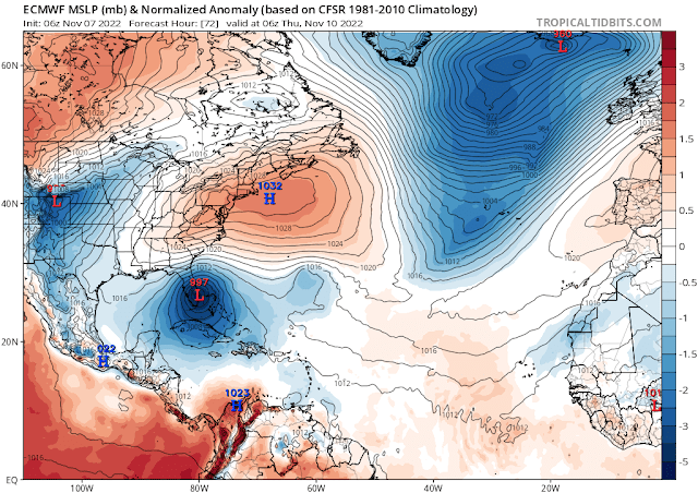
We begin the work week with the prospect of a tropical system impacting the East Coast of Florida this week. This is Subtropical Storm Nicole.
Dr. Phil Klotzbach from the University of Colorado says Nicole is the third named system in the Atlantic Basin since Halloween. The two others were Lisa and Martin. This is a record, the most activity post October 31st thru November 7th.
What is a Subtropical storm?
Where is it Headed?
The center of Nicole formed early Monday morning. Now that there's a good center spin, the models can gives us a better forecast.
- High pressure to the NE will push it towards the NW Bahamas and then the East Coast of Florida.
- It may approach as a category 1 system with winds around 75 mph sometime late Wednesday or early Thursday morning.
- It will then cut across the peninsula, stopped by a front and pushed back into the state. Just about all of Florida may be impacted by the storm.
Models
The GFS puts Nicole across South Florida by November 10th. Notice the high pressure system steering Nicole towards Florida in the short term.
- At least Tropical Storm Force winds (39 mph and above)
- Its forecast to be a hurricane as it near the NW Bahamas
- Torrential downpours, Rough surf, rip currents and coastal flooding.
- King Tides this week could make the coastal flooding problem worse.
Graphical Impacts
The local @NWSMiami office is offering their assessment of possible impacts for the area. Here's a good look as to what areas by be impacted by wind, rain, surge, or tornadoes. These will probably change as the system nears So FL.
Even though we are getting to the end of hurricane season, Mother Nature will decide when she is done with the tropics.
We'll keep watching


No comments:
Post a Comment