Monday, May 31, 2021

Hurricane Season 2021

The 2021 Hurricane Season has arrived. The National Hurricane Center (NHC) suggests we should see another active year.

Forecasters predict a 60% chance of an above average season, a 30% chance for near average season, and 10% chance for below normal activity. They add that we should not see a repeat of the historic number of storms that were spawned in 2020.


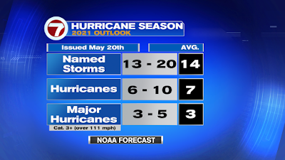
This year NOAA is forecasting 13 to 20 named systems, out of which 6 - 10 could become hurricanes, and out of that number maybe 3 to 5 may reach major hurricane status. Those are systems category three or above, having over 111 mph. If you compare that with was is typical of 14,7, and 3 it appears we should see more action in the tropics.

You will also notice the numbers that are now considered average are higher. That is because tropical formation in the tropics has increased over the last 30 years. The previous totals were 12,6, and 3.

Why the above average forecast?

  • El Niño, which is a warming of the Equatorial Waters of the Pacific Ocean, disrupts marine and atmospheric currents alike. When it is active, it causes hostile conditions in the Atlantic Ocean for systems to form and/or grow.  It will be absent this year. It's counterpart, La Niña, which makes the environment more conducive for storm formation,  may make an appearance towards the end of the season and raise the chances for tropical organization.
  • Warmer Ocean temps in the Atlantic Basin. Warm waters of over 80 degrees is the main ingredient in hurricane formation. Models are calling for temps to be above that mark.
  • Weaker Trade Winds
  • More moisture coming out of West Africa

Names


By the way, Tropical Storm Ana developed in May scratching off the first name on the list. 
If we run out of names like 2020, NHC will no longer use the Greek Alphabet to follow storms, instead a supplemental list of names has been issued.

Click here for Additional Names

Now is the time to prepare when everything is quiet. Review your needs and plan accordingly. Don't wait to the last minute. We'll do our part to keep you informed. The entire 7weather team of meteorologists will guide you through the 2021 season. Stay safe.


Saturday, May 22, 2021

New Named System in Atlantic

For the 7th consecutive year, hurricane season starts early.  Subtropical Storm Ana was called by the National Hurricane Center (NHC), early Saturday morning.


It has a nice spin to it on satellite imagery with a well defined center. Typically, subtropical systems have a cold core with most of their rain and wind away from the center. But Ana, may be slowly morphing into a tropical system as it is starting to get thunderstorms moving into that center spin. This may be short-lived however.

Where is it headed?

Ana is slowly moving west/southwest and is forecast to move even slower over the next 12-24 hours. Some of its gusty winds could reach Bermuda and thus they have issued a Tropical Storm Watch for that possibility. 

In the long term, a front pushed along by the Jet Stream coming out of Canada, will push Ana away from Bermuda and into the cold waters of the Northern Atlantic.  The cold waters there should prove fatal to the system. It will also run into shear, or strong upper level winds that will cut it down to size,  and drier air starving it of much needed moisture. NHC does not take the forecast any further than Monday.

Hurricane starts on Tuesday, June 1st and runs thru the end of November.


Friday, May 21, 2021

Two Areas to Watch

The National Hurricane Center (NHC), is monitoring the progress of two disturbances in the Atlantic Basin.


INVEST 90L

This first system is located roughly 500 miles ENE of Bermuda.  An Invest is an area NHC would like to INVEST-igate further, 90 is a tracking number, and "L" stands for Atlantic Basin. 

This spin has a high chance of becoming the first named system of the 2021 season. If it does develop, it will be called,"Ana".

It may form into a subtropical storm which is basically a system with a cold core and much of the wind and rain removed far from the center. 

Bermuda has issued a Tropical Storm watch because of the proximity to the system.  If it does develop, it should eventually move north into the cold waters of the Northern Atlantic. 

INVEST 91L

A good looking spin is sitting in the NW Gulf of Mexico. This area of clouds and rain has a medium chance for development at only 40%. 

Even if it doesn't organize it will drop more rain over areas that have seen plenty of downpours in the last few days. 

Texas and Louisiana have seen flood advisories since Tuesday.

Where are they headed?

Invest 90L


Its shows the system lingering near Bermuda, until the jet stream moves in over the next 24-48 hours. It will then swing NE, or turn southwest before heading out into the open waters of the Atlantic. No worries for U.S. interests.

Invest 91L


Upon moving onshore, the rain will travel across Texas and Louisiana. If the low survives, the remnant moisture could reach the Great Lakes region.  


We'll be watching


Thursday, May 20, 2021

New Seasonal Forecast, New Storm?

 The National Hurricane Center (NHC) issues the official forecast for the 2021 season.

They are calling for 13 - 20 named systems, out of which 6 - 10 could become hurricanes, and out of that number 3 - 5 may intensify into major storms. Those are category threes or above or those having winds over 111 mph.   Compare that with the new normal of 14, 7, and 3, and it appears we should see an above average year.  The new normals are higher than the previous 12,6,& 3 due to the fact that over the last 30 years we have seen more activity throughout the tropics. 


What this forecast can never tell us is where and when a storm could make landfall, so prepare as if we will get hit, and you should be ready for whatever Mother Nature sends our way.

2020 was a record setting year with 30 named systems. The most active year since record keeping began. NHC ran out of names and was forced to us the Greek Alphabet to follow storms. 

Use this time now before hurricane season really heats up to gather what you may need to weather any storm threat.

Early Tropical Activity


Hurricane season does not start until June 1st, but already NHC is following a disturbance capable of becoming the first named system. This spin in the Western Atlantic has a 80% chance of developing over two days, or a 90% chance over 5 days in the area highlighted in red.

The Latest Satellite imagery shows a surface circulation in the middle of the loop and away from the bright infrared colored clouds. If the center remains mostly cloud free and with a cold core, it could be classified as a subtropical system.


This feature is now Invest 90L. Invest for an area NHC would like to INVEST-igate further, 90 is a tracking number, (the next one will be 91, then 92, etc...) and "L" stands for the Atlantic basin.

Models

At this stage of the game, since nothing has developed, most models are providing an educated guess.  The few runs available suggest the system should stay over the open waters of the Atlantic .


We'll be watching.

Starting Tuesday June 1st, I will be launching a humble Podcast called "Weather or Not" where I'll chat about weather, science, space, and the occasional satellite falling from the sky. Check us out on Google, Apple, and Spotify.  Thank you so much.


Wednesday, May 19, 2021

A Disturbance in the Atlantic

The National Hurricane Center (NHC) is monitoring a disturbance in the Western Atlantic for possible development.

Hurricane Season doesn't officially start until June 1st, but already there is something to watch. 

Courtesy: Tropical Tidbits

On the satellite imagery above, if you look at the right center edge of the picture... that is the area NHC is monitoring. 

Watching for organization


NHC says, this disturbance has the potential to develop into a non-tropical low pressure system over the area highlighted in yellow over a period of 5 days. There is a 60% chance of this happening. A non tropical low is your basic counterclockwise spin with a cold center as opposed to the average warm core hurricane-like storm.

It may develop as early as Thursday, a few hundred miles NE of Bermuda, generating gale force winds of over 30 mph.The name would be Ana.

The Twist

The disturbance could drift southwest into warmer waters by the end of the week and acquire subtropical characteristics. This means it may look like your classic tropical system, but its center would still be cold, and it would also be cloud free with much of the rain and wind a good hundred miles away.

Forecast

NHC says, eventually whatever develops, if anything, would travel northeast away from any land masses and run into a more hostile environment by the weekend.

This is a good reminder that we should get ready for a season that lasts thru the end of November. Last year we had a record with 30 named systems. NHC ran out of names and resorted to using the Greek Alphabet to follow storms. Hoping this year will not be as active.

NHC will issue their 2021 forecast on Thursday.

If you would like to see a list of names for this year and for the next 5 years, click on the link


We'll be watching


Subtropical Storm Nicole

We begin the work week with the prospect of a tropical system impacting the East Coast of Florida this week. This is Subtropical Storm Nicol...