Monday, July 5, 2021

Elsa: Cuba & Florida

Tropical Storm Elsa impacts Cuba and then tracks near the Florida Keys. It's a ragged, not well organized system proving a tag difficult to forecast what its impacts will be for South Florida.


As of Monday morning, the system was holding its own, even with its center being so close to land. But its structure is a bit lopsided. Since Sunday, Elsa is leaning to the East at the top and to the west at the bottom with most of the cloudiness sitting on the eastern half.  It is a compact system with tropical storm force winds stretching out roughly 70 miles from the center. Clear skies are sitting to the north over Florida but some of that cloud deck should start reaching us today.

We will be watching for just how much impact Cuba has on Elsa and how strong/weak it is once it emerges into the Florida Straits.

Radar


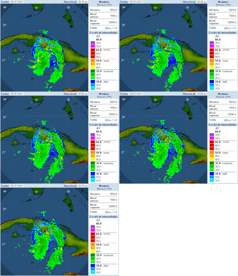
Cuban radar loop detects the rain from Elsa impacting the Central Part of the Island. Here too, the rain sits on the eastern side of the storm. It has not been able to wrap around the center, an indication of Cuba's terrain having an impact on the storm.

Impacts

Elsa's impact on Cuba will be the following: Heavy rain with significant flooding specially on the eastern side of the storm. Gusty winds and a possible storm surge on the southern side of Cuba.

South Florida: Elsa is very much a lopsided storm. This means that even if the center passes well to the west of the Keys, most of its heavy rain will be on the eastern half. Here's a list from NWS on the Possible impacts. Keep in mind this may all change depending on how healthy Elsa is after its Cuba Crossing.

NWS guidelines for South Florida:

Prepare for dangerous wind having possible significant impacts across the Lower Keys. Potential impacts in this area include:
- Some damage to roofing and siding materials, along with damage to porches, awnings, carports, and sheds. Mobile homes damaged, especially if unanchored. Unsecured lightweight objects become dangerous projectiles.
- Several large trees snapped or uprooted, but with greater numbers in places where trees are shallow rooted. Several fences and roadway signs blown over.
- Some roads impassable from large debris, and more within urban or heavily wooded places.
- Scattered power and communications outages.
Also, protect against hazardous wind having possible limited impacts across the Middle and Upper Keys.

SURGE:
Prepare for locally hazardous surge having possible limited impacts across the Florida Keys. Potential impacts in this area include:
- Localized inundation with storm surge flooding mainly along immediate shorelines and in low-lying spots, or in areas farther inland near where higher surge waters move ashore.
- Sections of roads and parking lots inundated by surge water. Driving conditions dangerous in places where surge water covers the road.
- Moderate beach erosion.
- Minor damage to marinas, docks, boardwalks, and piers. A few small craft broken away from moorings.
FLOODING RAIN:

Prepare for locally hazardous rainfall flooding having possible limited impacts across the Florida Keys. Potential impacts include:
- Flood waters can enter some structures or weaken foundations. Several places may experience expanded areas of rapid inundation at underpasses, low-lying spots, and poor drainage areas. Some streets and parking lots take on moving water as storm drains and retention ponds overflow. Driving conditions become hazardous.
TORNADOES:

Prepare for a tornado event having possible limited impacts across the Florida Keys. Potential impacts include:
- The occurrence of isolated tornadoes can hinder the execution of emergency plans during tropical events.
- A few places may experience tornado damage, along with power and communications disruptions.

Mainland South Florida

* A few strong to locally severe thunderstorms will be possible
  across South Florida this afternoon into the evening hours, with
  the primary concern being isolated damaging wind gusts. Present
  indications are that this risk may be highest across the northern
  portions of South Florida.

* Localized flash flooding from repeated rounds of heavy rainfall
  will be possible across South Florida, especially along the
  coastal/metro areas. Initially, this risk appears to be greatest
  across coastal/metro Collier County, with the risk increasing
  for the east coast metros during the overnight/morning hours.

* A couple tornadoes will be possible across South Florida, with the
  greatest threat across the southern and western portions of the
  area this evening into Tuesday.
The bottom line is that we will see some of Elsa's impacts across South Florida. How severe will depend on a number of things:
  • How much shear will still be present over the Straits 
  • How weak it emerges from Cuba 
  • Will its land crossing affect its track. Just a tiny bit eastward and we'll see stronger impacts while a bit more west, even less.
We'll be watching.

Sunday, July 4, 2021

Caribbean Elsa & then?

 On Sunday morning, the center of Tropical Storm Elsa was moving between Jamaica and Cuba and traveling away from Haiti & Dominican Republic.  Its next stop will be Cuba.


Elsa is proving to be a difficult system to forecast. Imagine you are looking from the top of the storm down to the ocean. Pretend the structure is an empty roll of paper towels. On a healthy system you would probably see straight down to the water. Not Elsa, all you would see are more clouds. That's because its core is more tilted, like the leaning tower of Pisa. This may be due to a few factors. Strong upper winds impacting it and land interaction of its feeder bands. We will look towards later missions for more details.

Recon Data

Conflicting reports from Sunday Hurricane Hunter flight: While its is looking physically better, its wind strength is coming down, from 65 mph earlier to 60 as of 11 am Sunday.

  • Cloud cover has built around the center 
  • Looks more symmetrical 
  • Has a healthier spin 
  • The wind center is removed from the spot it had been on earlier missions- A sign of disorganization
  • A new wind center has been spotted and it lies where the rain is heaviest - A sign of possible intensification 
  • Elsa has slowed its forward speed - May give it a chance to catch its breath

Because there is no real deterministic info on whether it will intensify, another flight is set for the afternoon.

Cone of Concern


The track has barely changed since Saturday morning. It will impact Jamaica & Eastern Cuba on Sunday - directly or indirectly. Keep in mind on the map above, the track shows where the center of the storm is or will be. Systems are much larger than that and heavy rain and gusty winds are capable over large areas outside of the cone.

On Monday as the system is over Cuba, it will start making more of a turn to the north. The Keys and SW Florida remain in the cone and should monitor closely.

Possible Impacts

The main concerns will be rain

  • Haiti, Jamaica & Eastern Cuba : Flash flooding with possible land & mudslides and gusts up to hurricane strength 
  • Central Cuba: More rain with flooding threat 
  • FL Keys & SW Florida: Monday to Tuesday the heavy rain slides in. Flooding is possible.  NHC adds there is an increasing risk of tropical storm conditions, storm surge, and rainfall starting Late Monday.  

The bottom line for Metro Broward & Miami Dade: While the center of the storm will pass over the Keys and into the Gulf, our area will be on the dirty sector of the storm. Outside of the center of circulation, this NE quadrant has the second most intense rain and wind with the potential to brew some tornadoes. Please remain alert.  While the forecast track models are confident in their forecast, any interaction with land could impact Elsa's trajectory.

We'll be watching

Friday, July 2, 2021

Elsa up to 85 mph Winds

Elsa is the Strongest July Hurricane in the Eastern Caribbean, since Emily in 2005. It hit Barbados and the Grenadine Islands Friday morning. Now it's en route for a possible confrontation with the Dominican Republic, Haiti, & Jamaica.


The satellite view shows a more robust system moving over warmer waters than 24 hrs ago. The forecast is coming into better focus in the short term. We'll detail what we know so far. 

NHC Cone of Concern


The main players are still in place. Elsa gets pushed west by High Pressure in the Atlantic. The high is drifting east and will eventually be far enough away to allow the storm to make a northward jog. When that turn occurs is still uncertain.

Models


The suite of models remain in unison through its approach of Haiti and Jamaica. Then they fan out as they do not know where the high will be exactly situated.

The Hurricane Weather Research and Forecast Model

First Frame shows the system just South of Dominican Republic by July 3rd.

The second frame has Elsa between Jamaica and Haiti. If the center stays away from the high terrain of the Dominican Republic and Haiti it may be able to keep its strength and not weaken. This will be something to watch. El Pico Duarte in Dominican Republic stands tall at over 10,000 feet. It is capable of disrupting the storm' circulation. The down side, is that it will cause a lot rain leading to flooding across Hispaniola. 


The third frame then places Elsa near Central Cuba. We will be watching for its intensity closely by then.


Final Frame: Places the storm close to the Keys. Could see heavy rain, gusty winds, and storm surge . The Mainland will be on the NE quadrant also known as the dirty sector. Because of the way a storm spins, outside of the center, this is the second most active part of a system. Heavy rain, wind gusts, and even tornadoes are possible. Miami-Dade and Broward Counties will be on this side.


GFS Global Forecasting System


In this animation you can see the Bermuda High shown as a big red blob. It pushes Elsa NW towards Cuba, Florida, and the Eastern Gulf of Mexico. 

Euro Model


This model has the high weakening and moving East quicker. Elsa may be a weaker system once it enters the Atlantic due to its interaction with land. 

Intensity

This is the most difficult thing for models to handle. While new improvements are making the projections better, they are still far from the accuracy enjoyed by the track models.

Saharan Dust

At this moment there is a huge plume of dust that extends from the West Coast of Africa into the Bahamas. This would usually dry the atmosphere around a system starving it of much needed moisture, but it is not happening in this case. Elsa is also traveling over warm waters and that could help keep it as a hurricane.  The islands down the road should stay alert. 


Levi Cowan of Tropical Tidbits publishes an intensity forecast. It displays what the models say Elsa may pack down the road in the form of winds.  

Zero hour (NOW) starts on the left and goes forward in time to the right. Some models call for Elsa to ramp up to a category 3 with over 111 mph winds in 60 hrs. Another bunch maintain it as Cat 1 through its life cycle, and another handful weaken it to tropical storm strength. 


As mentioned in the previous post, rain will be a huge issue. Everyone in the cone of concern should prepare accordingly. South Florida should take the time this weekend to ready storm plans in case Mother Nature plays dirty.  We'll be watching .


Elsa Impacting the Windward Islands

Friday has Tropical storm Elsa make its first landfall and turning much stronger. Winds went up from 50 mph Thursday night to 75 mph Friday morning 8 am. Elsa is now a hurricane.


All those red colors represent very high cloud tops. Those usually have the most rain associated with a storm.  Elsa is moving quickly WNW and is impacting the Island of Barbados followed by St. Vincent later Friday afternoon.  Rainfall forecasts call for anywhere between 3" - 10" leading to flooding and possible mudslides. A storm surge of 1' to 3' should move in along the coast as well.

Radar


Rain bands have been impacting Barbados to as far South as Trinidad and Tobago. 

Cone of Concern


High pressure in the middle of the Atlantic Ocean is pushing Elsa quickly W/NW. No change is expected in the short term. Many areas in its path have already issued watches and warnings.

Sometime late on Sunday or early Monday as it nears Central Cuba,  Elsa takes a turn northward.  It could then be near South Florida Late Monday or Early Tuesday. The National Hurricane Center (NHC) reminds us that the average cone error by days 4 and 5 is 175 to 200 miles. 

Models


The models are spread out determining where the system may end up. The GFS & UKMET project the high moving away slowly and thus track the system more over Florida and Eastern Gulf of Mexico.  A few models place the system across the Yucatan Peninsula. 

The European Model suggests the high moves quickly and keeps Elsa on a course into the NW Bahamas. NHC's forecast is a compromise of all these scenarios which keeps Florida in the Cone.

Strength

This is very tricky. While initial model runs on Wednesday and Thursday did not show more than 60 mph winds as it neared Florida, the system is now a hurricane. There is plenty of warm water ahead and it could get stronger. While the 8 am Cone weakens it back to a tropical storm,  Haiti and Jamaica  should pay close attention as  the system nears on Saturday. A reminder intensity forecasting is very difficult and storms can change rather quickly. Remain vigilant.

Elsa's strength looking ahead into Sunday and Monday, will depend over how much land it travels over. If it treks over the highest terrain in the Caribbean, Pico Duarte of the Dominican Republic, then it may be a weaker storm. But if the center stays over water as it moves into Cuba, we could see a much stronger system. NHC says the model gap is so wide, that while some call for it to completely fall apart others ramp it up to a category 3. This is why South Florida should keep an eye on it. 

Impacts

Puerto Rico has a chance for 1" - 3" of rain with some spots to 5". Flooding and Flash Flooding concerns there with a chance for mudslides. Minor river flooding is also possible.

Dominican Republic, Haiti, and Jamaica: Heavier rain forecasts here with totals projected to reach 4" - 8" with some locations up to one foot. Flash flooding is possible in spots with a threat for mudslides.

  • South Florida & Bahamas: With the large spread of computer models listed at the top of the blog, it is premature to say exactly what will take place. 
  • The Florida Keys should be more alert for the possibility of gusty winds, heavy rain, rough surf and even a tornado. 
  • The Mainland needs to keep monitoring. Even if there is no direct impact, we could see heavy rain that may lead to flooding. 
  • The SE Bahamas may see some rain from the outer bands as well as the Central Bahamas. NW Bahamas, you may get something stronger if the system makes an early turn towards you. 

Hopefully the models will provide better guidance by Saturday.  Everyone stay alert and stay safe.  We'll be watching.


Thursday, July 1, 2021

Tropical Storm Elsa

Tropical Storm Elsa took shape early Thursday morning making it a record setter. It is now the earliest fifth named storm to ever develop. The previous title was just from last year, Edouard from July 6, 2020. It is on course to impact most of the Caribbean Islands.


The satellite animation shows the system overnight thru early Thursday. It has a good spin moving quickly west. Feeder bands are becoming more evident over the last 12 hours, specially to the west and south of the system. 

The intensity models suggest some strengthening as it is moving over warm waters with very little shear. These are strong upper level winds that tend to keep storms in check. 

Models


The system is being propelled west by a dome of high pressure in the middle of the Atlantic. This will continue pushing Elsa WNW over the short term. In the long haul, the high will shift east, allowing the storm to take a turn north. That will be the issue for South Florida, when will that turn take place. Some models suggest an early shift into the Atlantic, while others delay it until the Gulf. Regardless, the state is in the middle. 

The European model, after not doing much with it over the last few days, now takes it more towards the Northwestern Bahamas. The GFS, HWRF, & UKMET models disperse it into the SE Gulf of Mexico. Will be interesting to see 

Cone


The official cone of concern, shows Elsa moving across the Windward Islands on Friday. Watches and warnings are in place there since Wednesday afternoon.  Gusty winds to 40 mph with rain totals between 3"- 8" are possible across the Southern Leeward Islands including Barbados. Flooding along with land and mudslides are possible.

Elsa will then enter the Eastern Caribbean Sea and into warmer waters, but due to its quick forward movement, it may not be able utilize that additional fuel to grow much stronger. NHC is keeping it as a storm through its lifecycle. We know intensity can change at any time so we will monitor it closely.

Puerto Rico remains south of the cone but not without indirect impacts:

  • Heavy rain is forecast by Friday night 
  • Gusty winds 
  • Rough Surf 
  • 12 foot Seas

Elsa should slow down as it nears Dominican Republic, Haiti, Jamaica, & Eastern Cuba. This is when it should begin its gradual turn northward.  A front coming off the Nation's midsection should help steer it that way as well.

Any interaction with the islands may have an impact on its health as well. 

The Dominican Republic has an Orange Alert for possible Flash Flooding. Haiti, Jamaica, & Cuba are waiting to issue advisories.

Florida & NW Bahamas

These areas need to closely monitor the path of the storm. Even if its not a direct strike or a hurricane, the impacts could be great. Last year a nearby tropical storm caused heavy rain in Ft. Lauderdale leading to very serious damages and power outages. Please be prepared. We are after all in hurricane season.

We'll be watching.


Subtropical Storm Nicole

We begin the work week with the prospect of a tropical system impacting the East Coast of Florida this week. This is Subtropical Storm Nicol...