Wednesday, June 30, 2021

One fizzling, another ramping up

The National Hurricane Center (NHC), maintains its focus on two waves in the Atlantic Ocean. One has its chances for development lowered while another keeps showing signs of organization.


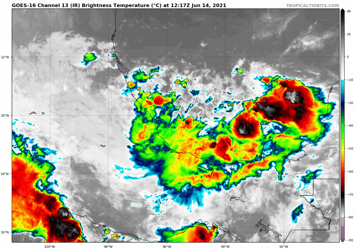
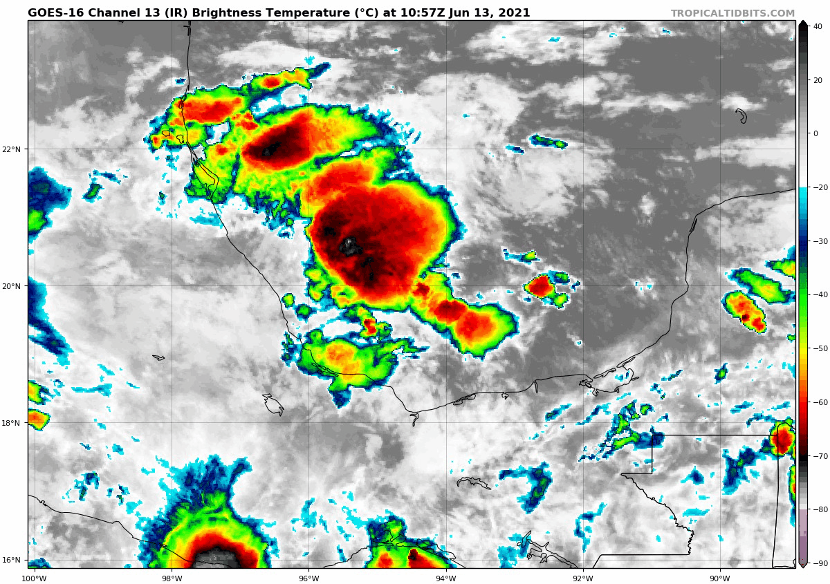
On the Satellite image, on the center of the screen there are two cloud masses. The first is the weak wave by the Lesser Antilles, the second to its right is the more vigorous wave. We'll start with the one closest to the Islands.
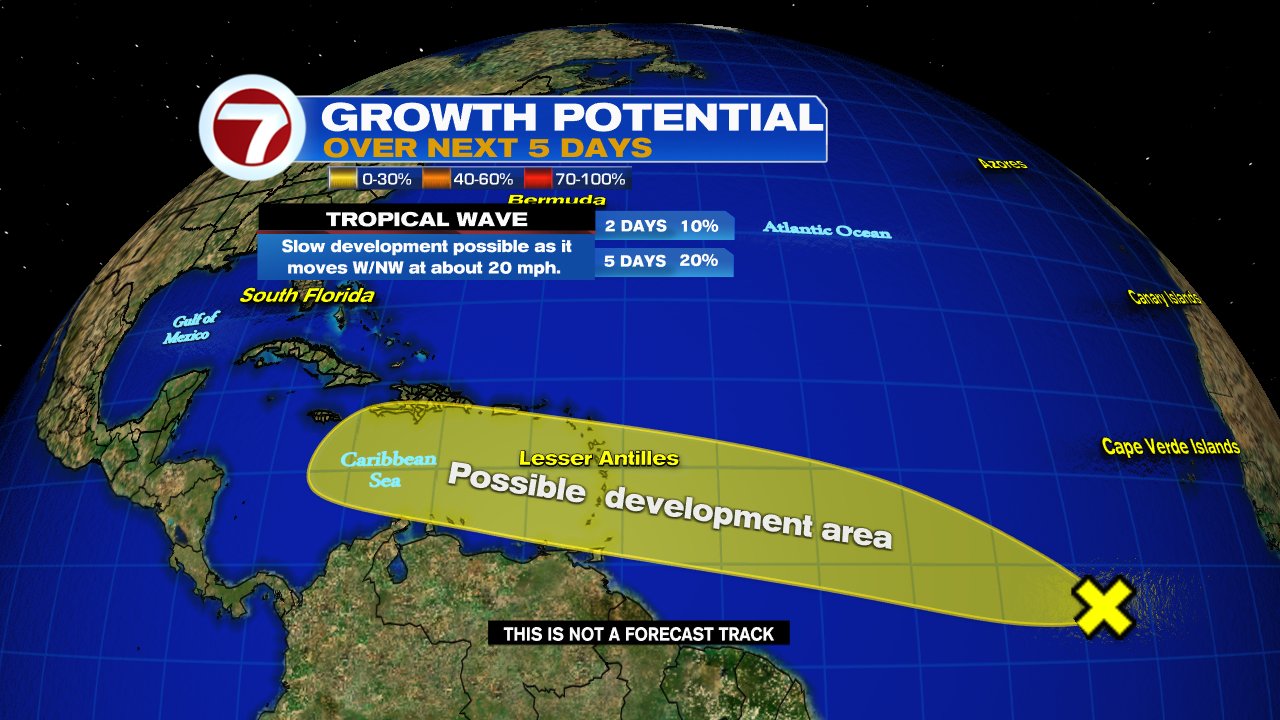
Wave # 1


This is the early Wednesday morning Satellite view of the Lesser Antilles. This wave has a few showers and thunderstorms. It's moving west at 20-25 mph. 


Its chances for development keep coming down from a high of 40% a few days ago to just 10% Wednesday morning. If it were to develop at all, it would do so in the area highlighted in yellow over a period of 5 days.

Even if it doesn't form, most of the Lesser Antilles, Virgin Islands, & Puerto Rico could see some of its impacts. NWS says the wave is still capable of:

  • Heavy rain through Thursday 
  • Some isolated flooding 
  • Rough Surf & High Seas

Wave #2


It's looking better organized and is now a broad area of low pressure. This is the first indication that it has the potential to become a depression or a tropical storm. It's situated between the Lesser Antilles and the Coast of Africa. Its present movement is WNW at about 20 mph. You can see from the sunrise view that it is getting that well defined tropical spin to it.


NHC is giving it a high probability, an 80% chance, that it could develop into a depression over the next few days. It will follow in the footsteps of the 1st wave, so everyone across the Lesser Antilles and Eastern Caribbean Sea should monitor closely. Even though there is some Saharan Dust to its north, its not being greatly impacted at the moment. 

Models


This Broad Low has been designated Invest 97L, since its inception. These model runs have been consistent since the start of the Invest, and show a possible track through the Windward Islands, then Eastern Caribbean, through Cuba and possibly South Florida. Keep in mind until something forms, they are still just giving us an educated guess. But we are in hurricane season and we should monitor the progress of any activity.

South Florida / Bahamas

Still too early to know with any assurance of what impacts if any, that we'll see from this broad low. Just keep checking back from time to time to get the latest info. We'll be watching.


Tuesday, June 29, 2021

On Wave Watch

Tuesday morning had the National Hurricane Center (NHC), keeping tabs on two tropical waves in the Atlantic.


Find the Lesser Antilles in the center of this picture. To the right you will see some clouds, these are the two waves being monitored by NHC.

Area Number One (Invest 95L)


This wave is about 800 miles East of the Lesser Antilles moving in their direction at around 15 to 20 mph.  It has a 40% chance that it could become a depression/storm somewhere in the area highlighted orange over a period of 5 days.  It could be close to the Islands by Wednesday.

Models


Nothing has developed yet. IF it were to organize, this is what the early model runs suggest. Keep in mind since nothing has formed, the models are providing only an educated guess. It gives us an idea of a possible track. 

Parts of the Lesser Antilles could see rainfall by midweek from the wave. 

Both waves are being nagged by dry air in the form of Saharan Dust and that could keep them in check. The dust shown here in bright oranges and reds is moving west along with the waves.

Area Number 2 (Invest 97L)


Has a 20% chance for development anywhere in the yellow area over a 5 day span.

Models


Once again, these are just preliminary projections. Models need to have a well organized system to provide accurate forecasts. They show a possible track towards the Windward Islands and then into the Central Caribbean. Still, too many factors in flux to get a good handle on its future.

Tropical Storm Danny


Spun up quickly from Tropical Depression 4 on Monday afternoon. It made landfall near Hilton Head, S.C. with 40 mph winds. It fell apart very early Tuesday morning.

I will keep you updated on any changes regarding the tropics, on-air, on-line, and on social media.

We'll be watching


Thursday, June 17, 2021

Recon into Invest 92L

The National Hurricane Center (NHC) should get some insight today into a disturbance in the SW Gulf of Mexico from planned hurricane hunter recon. Two missions are tasked.

ATLANTIC REQUIREMENTS
    1. SUSPECT AREA (BAY OF CAMPECHE)
       FLIGHT ONE - TEAL 71
       A. 17/1730Z
       B. AFXXX 01AAA INVEST
       C. 17/1515Z
       D. 21.0N 93.0W
       E. 17/1700Z TO 17/2200Z
       F. SFC TO 10,000 FT

       FLIGHT TWO - TEAL 72
       A. 18/1130Z,1730Z
       B. AFXXX 0203A CYCLONE
       C. 18/1000Z
       D. 24.5N 93.0W
       E. 18/1100Z TO 18/1730Z
       F. SFC TO 10,000 FT

Notice flight one has the disturbance identified as an Invest, while flight 2 already has it as a cyclone.  This may be a heads up that organization may be swift on Thursday.

Satellite View


The actual spin of the broad low is sitting rain free across the Bay of Campeche in the SW Gulf of Mexico. The rain is getting displaced by strong upper level winds and shoved towards the Northeast. South Florida and the NW Bahamas may still get some of this tropical moisture on Thursday. Scattered downpours are still possible. 

Models

The spaghetti plots show that whatever develops will move northward and aim for the Gulf States. 


The Euro and GFS are in agreement this morning on where and when the system could make landfall. Both place the center of circulation over Coastal Louisianan on Saturday.  The European has a slightly wetter system than the GFS.

Euro


The GFS


What to Watch


This is an interesting Satellite picture. A filter is being used to detect Saharan Dust blowing to the West. Some of it could arrive late Thursday afternoon and help dry us out. It should keep us rain free thru Saturday but Sunday it starts to move into the Gulf and things begin to change. It's unknown at this moment how much of an impact it may have on the developing system.

There is an outside chance that while the disturbance heads north and away from So FL,  some of its moisture could get flung our way. This may start upping our rain chances for the second half of the weekend and possibly Monday.  Once the system develops we should get a better handle on our forecast.

 We'll be watching.


Wednesday, June 16, 2021

System to form in Gulf?

There is a high chance this mess of clouds and rain sitting over the SW Gulf of Mexico, could become a named system soon. It is currently drenching parts of Central America and Coastal Mexico.


Even though its far away rom South Florida and no direct threat to the area, we will sees some of its moisture get whipped our way. The satellite imagery shows how some of the disturbance's rain is being flung in our direction. 

The Health of Invest 92L

Location: Roughly 18.1°N 94.3°W 
Maximum Winds: 25 mph Gusts: 35 mph
Minimum Central Pressure: 1009 mb 
Environmental Pressure: 1011 mb 

  • It remains disorganized 
  • Very close to land, and that's keeping a good circulation from forming 
  • There's plenty of hot water and that could give it a chance to grow once it starts moving north
  • As of Wednesday morning it has a 70% chance for development over 2 days and 90% in 5 days.

Models


The spaghetti models suggest a northward track. It may end up anywhere between Texas and the Florida Panhandle.

The GFS Model


This models places a system close to Louisiana and Mississippi with the potential for very heavy rain.

Euro Model


This forecast takes whatever develops on a more westerly track, with the center possible aiming for Texas and Louisiana.

What can we expect from this system

While it poses no direct threat at this time, moisture from it will continue to get flung our way. In the short term we start to dry out by Friday as Some Saharan Dust moves in, but it quickly dissipates. On Sunday as the feature in the Gulf gets better organized (and depending on its track) we could see some rain from it arriving in South Florida by Sunday into Monday. This is still far out and there are many variables to contend with. It all depends on the disturbance. I'll keep monitoring.

Weather or Not

In a related note, as Saharan Dust moves in, last year at this same time the Atlantic Basin was dealing with Godzilla, not the fictional monster, but the world's largest Saharan Dust cloud.  Can it happen again? Check out this weeks' podcast of Weather or not. And if you can, please subscribe, it would make my boss happy. Thank you

Click here for the Podcast: Weather or Not?


Tuesday, June 15, 2021

Short Term Bill & 2 others

A tropical storm in the Western Atlantic by the name of Bill promises to be a short lived system. It is forecast to fall apart sometime on Wednesday as it nears the Canadian Maritimes.


It is holding its own as of Tuesday morning with some impressive offshore rain bands, but in another 24 hrs, colder waters and shear or stronger upper levels winds, will spell the end of Bill.  It should then be near New Foundland.

Bill developed on June 14th, over one month ahead of the average date of the second named system in a season, that being July 16th.

Two Other Areas


The National Hurricane Center (NHC), is keeping tabs on two other areas for possible development.


The first disturbance is a broad area of low pressure in the SW Gulf of Mexico.  It really looks unhealthy on satellite imagery. The rain is not organized and you can't really make out a spin at all. NHC says this low will stick around the Bay of Campeche for a few more days dumping plenty of rain across Coastal Mexico. 

Eventually it should start to make a move northward. This is when the U.S should start to eye it closely. By the end of the week it could develop into a depression or a tropical storm. Some rain from the system could begin arriving near Texas by then as well. Chances for development stand at 70% over a period of 5 days.

Models
 

This is Invest 92L. The short term model tracks keep it very close to the Mexican Coastline, but by day 5, the system appears to head north towards Texas, Louisiana & even the Florida Panhandle.  No impacts are forecast for South Florida at this time.

The second area NHC is watching is in the Far Eastern Atlantic.


Its a bit early in the season to start looking at waves off the West Coast of Africa, but nonetheless, here we are. You can see the push of clouds moving west, but it is surrounded by Saharan Dust. This plume should starve it of needed moisture to grow, so we are not expecting too much from it. NHC is giving it only a 10% chance for growth.

We'll be watching


Monday, June 14, 2021

Three in the Tropics and Saharan Dust in So FL

Fourteen days into hurricane season and the National Hurricane Center (NHC) is following three areas. New Tropical Depression two, and two other areas for possible development. Bill would be the next system in line if the depression intensifies further. We already had Ana even before the season started.


Here's a look at the Tropical Trio. They span from the Far Eastern Atlantic all the way to the Gulf of Mexico.  We'll begin with the one that could potentially become Tropical Storm Bill, sometime later on Monday.


A good looking spin developed around 100 miles SE of Cape Hatteras, NC. As of 11 am Monday, advisories started on now classified Tropical Depression 2


Most early models suggest a track away from the U.S. Canada may have to watch it a bit more closely.


Chances are also increasing for a system to develop in the SW Gulf of Mexico. It has a 60% chance for organization as it drifts near the Mexican Coast. Even if it doesn't form, heavy rain is possible for parts of Central America and Coastal Mexico.  

This is Invest 92L. Most models keep it in the Bay of Campeche. The two models showing a northward jog are the XTROP & CLP5. The XTROP says, if it has been slightly moving North over the last 12 hrs, it will continue to move in that direction the next 12 hrs. The CLP5 is mostly historical. A look at average tracks other systems took that developed in that area.


The third area being eyed by NHC is in the Far Eastern Atlantic.


A strong Tropical Wave hugging the West Coast of Africa is being given a low chance for growth. It is expected to run into a big road block in a few days in the form of a huge plume of Saharan Dust. NHC is giving it a 20% chance for organization over 5 days. 

Saharan Dust on the Move


Great shot from Space showing the dust plume which has already moved into the Eastern Caribbean Sea. Model forecasts suggest that Cuba, NW Bahamas, & South Florida could see some of that dust by the end of the week or weekend.  The dust is an irritant and a bigger health concern for folks with respiratory issues. 

We'll be watching 

By the way, last year at this time we had the biggest Saharan Dust Cloud on record. It was nick-named Godzilla. Our 7Weather podcast "Weather or Not?" Has a look at the reasons why it happened. Check it out on Spotify, Apple, or Google.


Sunday, June 13, 2021

Gulf System?

The National Hurricane Center (NHC) is watching a trough (an elongated area of low pressure) in the Gulf of Mexico for possible development.

Courtesy: Tropical Tidbits

It is sitting in the Bay of Campeche in the SW Gulf of Mexico. There is plenty of clouds and rain there and slow development is possible in the next few days. NHC says a depression may form by the end of the upcoming work week. They caution, even if it doesn't develop, heavy rainfall is possible across parts of Central America and Mexico. 

Chances for Growth


This disturbance will crawl along in the Gulf of Mexico. Over the next 5 days, it has a 50% chance for developing into a depression/storm. As of Saturday night, very early model runs suggested some of the rain could eventually make it to the Gulf States. As of Sunday morning, those models are hinting at a more westerly track for whatever develops. If it were to organize, it would form earlier than the average second system of the season which is July 16th.

A second area has popped up as of the 2 pm Sunday update. It has a 20% chance for development just East of the Carolinas.


Invest 92L


NHC has deemed the Gulf feature Invest 92 L.  Invest for an area they would like to INVEST-igate further, 92 is a tracking the number, and "L" stands for Atlantic Basin. At this moment, the trajectories take it WSW. Keep monitoring as that could change as well. Slow moving systems like this one are extra difficult to forecast movement. 

In other Tropical News... SAL


A huge plume of Saharan Dust has made it west to Dominican Republic and Haiti. If models are correct, some of that dust could make it into South Florida by late next week. This should dry us out after what is set to be a very wet start to the work week.


We'll be watching


Friday, June 11, 2021

Watching the Gulf of Mexico

 The National Hurricane Center (NHC) is keeping an eye on the SW Gulf of Mexico for possible tropical development next week.


There is some cloud cover there now with moisture but otherwise it is mostly quiet.

NHC Chances for Organization


 NHC suggests that an area of low pressure could develop along the Bay of Campeche in the SW Gulf. 

 They are giving this possibility a 30% chance of organization anywhere in the area highlighted in yellow.

What are models suggesting

Keep in mind nothing has developed so at this stage of the game models are giving us an educated guess.

The GFS Models says that if we do get some formation, it may aim towards Coastal Louisiana by Friday of next week.

The Euro model has whatever features develops, in the middle of the Gulf Thursday evening.

Even if Nothing happens, an Upper Trough, or an elongated area of low pressure over Mexico, is set to carry plenty of Tropical Moisture towards the Gulf States. That could lead to flooding concerns.


We'll be watching


Monday, June 7, 2021

Caribbean Rainmaker

The National Hurricane Center (NHC), is following an area of disturbed weather across the SW Caribbean Sea. There's plenty of clouds and rain in the region and it should persist for much of the week as it moves West.

NHC says the disturbance has a 30% chance for development in the area highlighted in yellow over a period of 5 days.

Even if nothing organizes, the rain will move over many areas on & off from Panama north into Costa Rica, Nicaragua, and possibly Honduras. These rainfall totals could lead to flooding.

There are a handful of other areas in the Tropics, but all are of little consequence. However, the huge plume of Saharan Dust that's emerged out of the West Coast of Africa may reach the Caribbean in the next few days. It may cause hazy skies and be a concern for folks with respiratory issues. Be Alert.

We'll be watching


Subtropical Storm Nicole

We begin the work week with the prospect of a tropical system impacting the East Coast of Florida this week. This is Subtropical Storm Nicol...