Wednesday, April 6, 2022

Extended Stay

Scotland
My lengthy and unexpected stay in Edinburgh, Scotland.

It was the middle of March and my wife, oldest son, and myself were taking a long anticipated trip to visit our youngest son in Scotland.
David has been studying there since the start of Covid through lockdowns and such, and we were bubbling with anticipation to see him.
We landed in Edinburgh on Thursday, March 17th for a 3 hour tour… in all seriousness, for 10 days.
What a magical, historic, and vibrant city, with a blend of “middle ages” buildings peppered with new modern buildings.

Castle to the left and to the right with the city center in the middle.

Pubs, cafes, restaurants, and shops sit side by side as far as the eye can see tempting you to expand your waistline or lighten your wallet.

Cuisines from all over the Eastern Hemisphere abound, from Africa to India, Asia, Mid East, Europe and yes the occasional stray from the west… Mexico. 

Although a few restaurants claim to have Cuban dishes, they turn out to be some form of Mexican food.
Maybe I can retire here and earn spare cash making the real thing with some strong cafecito and croquetas. The Scots will never know what hit them! But I digress.

Geology
For science lovers like myself, the city has a plethora of geologic sites.
Your first Scottish greeting comes from a beautiful feature the locals refer to as a hill, but is more widely known as Arthur’s Seat.
Legendary "Arthur's Seat"

It’s a magnificent display of what once was the inside of an extinct volcano. It gets its name from Camelot and the fabled King Arthur who allegedly won some battles here.
I must have taken dozens and dozens of pics and not one did it justice.
I had shots from the base and some near the top and while the eyes and the soul were tickled in real life, it didn’t come across on my iPhone
The Seat from the ground where it was nice & quiet

Mid way up the hill enjoying the beautiful wild flowers

It got very windy and somewhat rainy near the top, so decided to head back down.
After a quick exploration of the old volcano, it was off to see the school.

University of Edinburgh
We eventually made our way to the University and took in the sights. Here too the college blends the past with the present. The city is adorned with castles and utilitarian buildings that make the college a true international campus with a flair for history.

One of the many libraries for the school

More modern teaching buildings

School Emblem

Arthur's Seat to the left / School building on right
This castle next to the “Seat”, is an administrative building for the school!

Harry Potter?
It is widely believed this city is the birthplace of the young wizard boy.
Wide View of a local cemetery 

Gates of the cemetery 

Tom Who?

While it’s unclear if J.K. Rowling really penned the sorcery novels here, (she’s changed her story a few times) there are plenty of references found in the books. Inside the gates of a local cemetery, there are several names on gravestones that appear in her writings.
If you look closely on the marker to the left, you will find a very important one.

Allergies
We explored the city over the next few days. Warmer temps and sunny skies cued Mother Nature it was time for flowers, buds, and…


...Pollen! Lots of it.
My allergies perked up and I developed my usual runny nose, but it didn't hold me back from enjoying the offerings. I checked out the local museum which features the first cloned sheep "Dolly". She hasn't looked better.
The museum of Natural History - NO Charge

And from the huge...

To the not so big... "Dolly"

The annoying runny nose stopped after a couple of days and we trained out to Glasgow, a mere 45 minutes away.


I can't rave enough about this form of transportation. Beautiful clean trains are everywhere with wide, comfy seats. Best of all you arrive 15 minutes early, board and go.

Glasgow
Our trip here was not part of our itinerary, but it was a great adventure nonetheless. A roommate of my son happens to be an admirer of our "Weather or Not" podcast. Jack, sporting a nice red jacket in the picture, became an even bigger fan when we dedicated a whole issue to the COP26 conference held last year in Scotland. This is a global climate change get-together aimed at curbing the world's Co2 emissions.

Jack gave us a nice tour of his hometown, a gorgeous city dripping with history, culture, and modernism...

Our host, Jack, in the red


... he also invited us to dinner with his family. And then it was time to head back to Edinburgh.
Oh No!
After days of fun, food, and Ferro time, we now had to test for our return trip home. On March 26th, everyone tested negative for Covid, except me. This explains the two days of runny nose, but outside of that, I had no other symptoms. No cough, no fever, no body aches. Thank goodness for the shots!

My family came back on March 27th and I stayed behind in quarantine. My youngest checked up on me daily while I tried to make the best of it. After all, I did not feel sick in any way.
I had a nice room with a view, and even a friend of my son lent me a guitar to pass time. It was great!
My nice downtown hotel


Released
After what seemed like an eternity, my third follow up test on April 3rd, finally cleared me to fly. Now I just had to book a flight back. The soonest was on April 6th. This meant some one-one-one time with David.
Rosslyn Chapel
We decided to go see the chapel made famous by Dan Brown in his novel the "DaVinci Code". It's featured near the conclusion of the film. What a beautiful site.


But the best discovery was the Rosslyn Castle next door, or what's left of it. It's free to see, magnificent, surrounded by nature, and did I mention it's FREE?


Everything Comes to an End
We spent our last night walking and talking about things. That was the real treasure. These are all night shots of the Royal Mile in Edinburgh.


So this explains why a short vacation turned into an extended layover. Thank you for your concern, questions, and patience and above all the great 7Weather team that always pinches in at the drop of a hat.

Saturday, September 25, 2021

Strong Sam

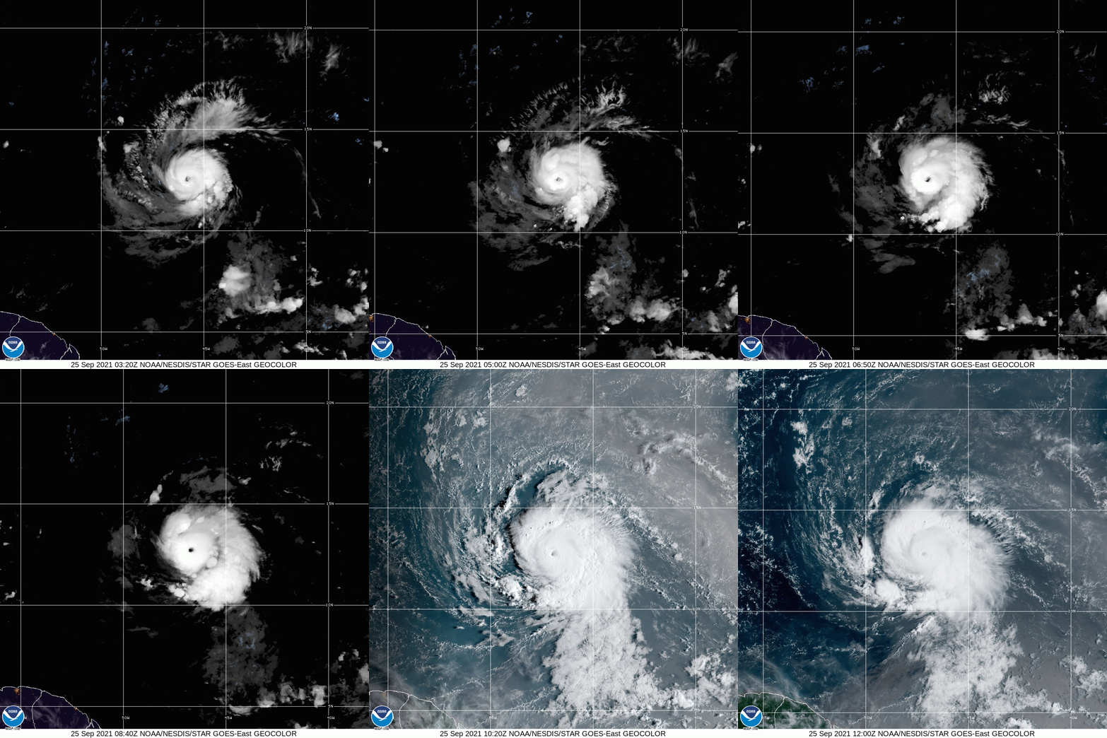
Hurricane Sam is on the cusp of becoming a Major Hurricane, category 3, Saturday morning. It is an impressive small, compact, yet powerful system roaming unimpeded in the Atlantic Ocean.


The satellite imagery from early Saturday clearly shows the "eye" or center of the storm. The eye wall which surrounds it, is where you find the business end of Sam. This ring of destruction, is what we will be watching closely as it moves West-northwest in the days ahead.  

The wind field is modest for the moment. Hurricane force winds over 75 mph, extending out from the center a mere 15 miles with tropical storm force winds of over 40 mph, out to 60 miles.

Sam is traveling slowly over very warm waters and will soak up all this heat energy and achieve Cat 4 status by Sunday. As it nears the Islands, a bit of Shear (strong upper level winds) should pause its growth cycle and slightly weaken it back to a category three.

Recon Missions are tasked for Sunday. Starting with NOAA high altitude recon followed by USAF Hurricane Hunters. This data will help get a better understanding of Sam's structure and atmospheric surroundings.

Where is it Headed?

A big dome of High Pressure in the Atlantic is the main driver in pushing Sam to the West. In about 4 - 5 days, the high begins to move East permitting Sam to start a northward jog. This should allow it to turn away from the Islands. At the same time, a front moves off the Eastern Seaboard, keeping Sam away from the Bahamas, Turks & Caicos, & Florida.

As it leaves the vicinity of the Leeward Islands, it will start to pick up some forward speed. Down the road, the Northeast and Canadian Maritimes may have to deal with Sam. 

Models


Models are in fair agreement the center of Sam should pass NNE of the Leeward Islands, Virgin Islands, & Puerto Rico.


The NAVY model illustrates extremely well what should happen in the days ahead. The tight swirl in the middle of the map is Hurricane Sam. The orange surrounding it is High Pressure. The High will develop a weakness or a gap as it slides East, to which Sam will travel through.  The path in the Atmosphere may take it close to New England, but it is too early to tell.

If all the forecast projections pan out, Sam should be a worry for Marine Interests. Lets keep our fingers crossed.

We'll be watching


Friday, September 24, 2021

Hurricane Sam

The National Hurricane Center (NHC) is tracking what will soon become Major Hurricane Sam. It is now the 7th hurricane this season. In this edition we will cover:

  • Health of the System 
  • Cone of Concern
  • Forecast Models 

Health

Satellite view 


Hurricane Sam, is starting to show the classic Buzz-Saw look. It is small in scale yet it has a well defined center with feeder banding that wraps all around it. These feeder bands (cloud tails spinning into the center) soak up heat energy from the ocean and transport it to the core. This fuels the tropical engine. For the moment, there is some space between the bands and that is keeping Sam in check. For the moment.  The wind field remains small stretching out only about 15 miles from center.

Cone of Concern


High pressure in the Atlantic Ocean is the main driver in propelling Sam to the West. The high is forecast to weaken and open a pathway for the system to take. The question, as always, is when and where will this weakness take place. The official cone from NHC has Sam starting to curve northward Wednesday.

Models


The GFS (Global Forecast System), also known as the American Model, has Sam (L in the middle of the screen. The L to the right is a wave coming off Africa), finding a weakness in the Bermuda High (shown in the orange color). This allows the hurricane to miss the islands and track into the middle of the Atlantic. Hopefully it will miss Bermuda as well.


The ECMWF  (European Centre for Medium-Range Weather Forecasts), places Sam in just about same spot as the GFS. These are only two of the dozens and dozens of computer models that forecast tracks. Most are in the same ball park.

At the moment, Sam will be feasting on plenty of hot water. It will not encounter any atmospheric roadblocks to weaken it.  Intensity forecasting is one of the most difficult things to achieve. The Leeward Islands should watch closely. It could get too close for comfort with wind speeds around 125 mph. I would suggest they prepare accordingly.

It appears Florida will stay in the clear, but keep an eye out just in case Mother Nature throws a curve ball. In the long run the Eastern Seaboard should watch carefully. 

We'll be watching as well. 


Monday, September 13, 2021

Tropical Trio

The week begins with the National Hurricane Center (NHC), tracking and following three areas throughout the Atlantic Basin. A Tropical Storm in the Gulf, a system-to-be East of Florida, and a concerning wave in the Eastern Atlantic.


We begin with Nicholas

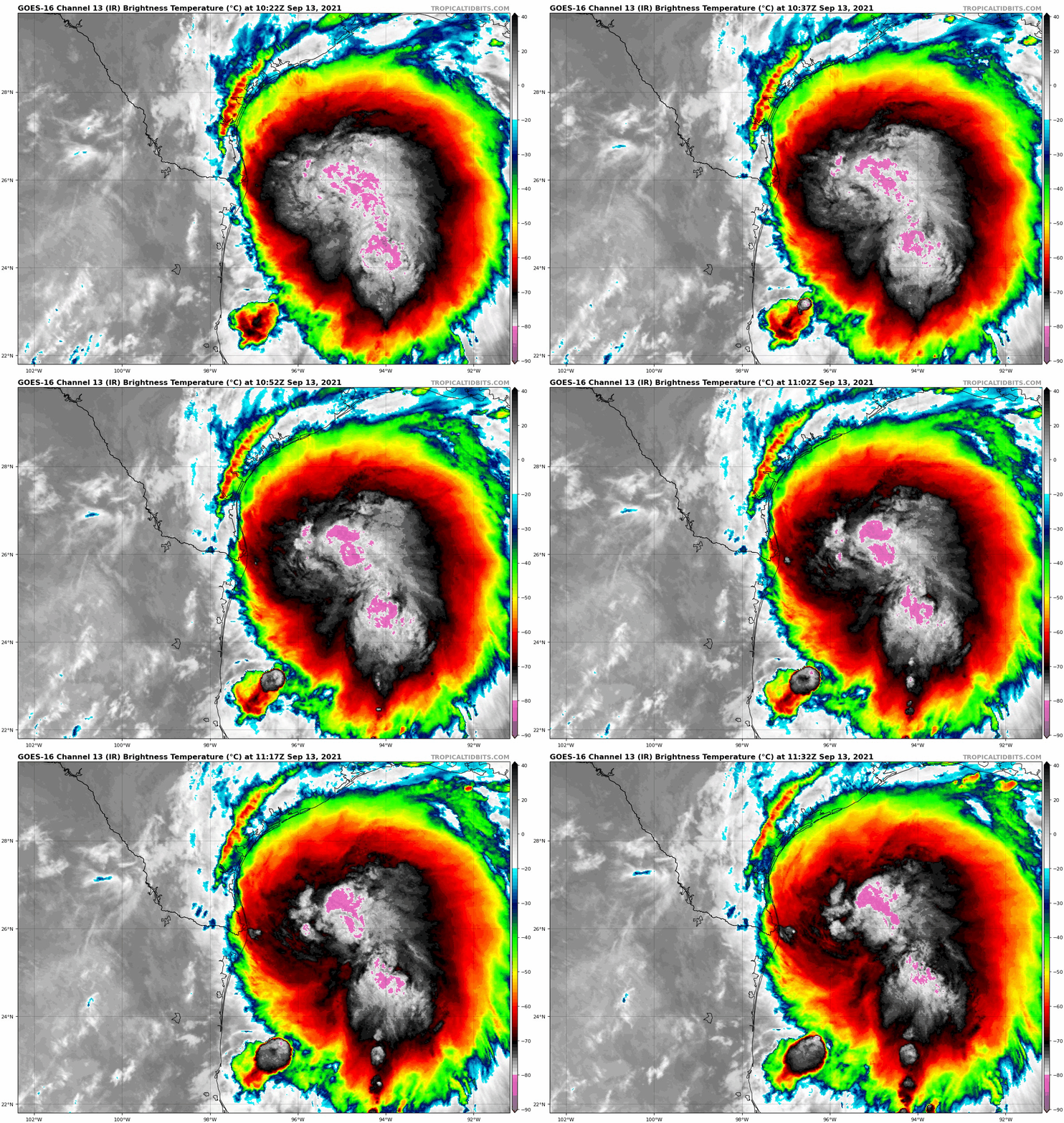
Courtesy Tropical Tidbits

A curious thing happened with Tropical Storm Nicholas overnight, the center (used to track its place and movement) reformed farther north than earlier on Sunday.

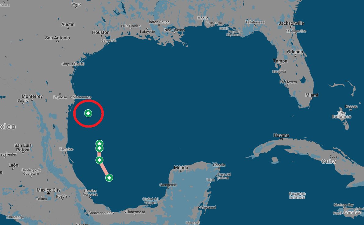
Courtesy Josh Morgerman

Reviewing its recent track, you can see where the center was, and where it can be found presently. It made a huge leap. This means  less prep time for folks along the coast of Texas.

Landfall Site?


The system may be too close to shore fur further intensification, but rain will be a concern.

Impact Data from NHC

Heavy rainfall will impact portions of the Texas and Louisiana 
coasts through the middle of the week. Significant rainfall amounts 
are possible, potentially resulting in areas of considerable flash 
and urban flooding, especially in highly urbanized metropolitan 
areas. Isolated minor to moderate river flooding is also expected. 

2. There is the danger of life-threatening storm surge inundation
along the coast of Texas from Port Aransas to San Luis Pass.
Residents in these areas should follow any advice given by
local officials.

3. Nicholas is forecast to approach the middle Texas coast as a
strong tropical storm today, and could be near hurricane
intensity at landfall.  Tropical storm conditions are expected 
along portions of the middle Texas coast beginning by this 
afternoon, with hurricane conditions possible from Port Aransas to 
Freeport this afternoon and tonight.

4. Tropical storm conditions are expected along portions of the
northeastern coast of Mexico and the coast of south Texas beginning 
during the next few hours.

Area East of Florida


This is a great NOAA satellite image of night turning into day across the Western Atlantic. The area of clouds to the East of Florida now has a 50% chance for organization somewhere in the area highlighted over a period of 5 days (See map at top of blog). If it develops it should move on a north/northwesterly track. 

New Wave by West Africa


This is Invest95L. You can barely make out the West Coast of Africa. That mass of clouds and rain has just moved offshore. It could develop anywhere in red shaded area. (See above Map)

Where may it go?


Early model runs show a W/NW track. Many things are in play here. A slow moving system would make it stronger while a faster one should keep it weaker. Models at the moment are still getting their footings with this new disturbance. Anything developing in the sector should be watched and monitored. It has an 80% chance for organization and may develop into a depression/storm sometime later this week.


We'll be watching


Subtropical Storm Nicole

We begin the work week with the prospect of a tropical system impacting the East Coast of Florida this week. This is Subtropical Storm Nicol...