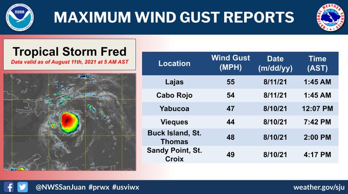
The National Hurricane Center is tracking Tropical Storm Fred. Upgraded from Potential Storm 6, as of 11 pm Tuesday.
The forecast track should remain mostly the same with the exception of minor fluctuations north and south. Intensity will also tick up or down depending on the impact of Pico Duarte on Fred. This is the highest terrain in the Caribbean. It can shred the system or deflect it in another direction.
IMPACTS
Fred should move onshore Dominican Republic Wednesday. The main impact will be in the form of rounds of rain.
These are the local storm advisories for Dominican Republic. The highest alert in red.
If Fred, survives its brush with land and Pico Duarte at over 10 thousand feet tall, it could pass by the SE Bahamas, Turks & Caicos by Thursday. It would then travel just north of the Cuban Coast & south of the Central Bahamas on Friday.
Rain Forecasts
If models are correct, this systems should not be a wind event, more a rain event.
Puerto Rico & Dominican Republic: 2' - 4" of rain with some spots as much as 6". This will lead to the threat flooding, land and mudslides. Flood Alert remains in place for Dominican Republic.
Haiti, Turks & Caicos, SE Bahamas, & Eastern Cuba: 1" - 3" with isolated spots up to 5". No Flood Advisories have been issued yet.
South Florida: MAY see some gusty winds and rain starting Friday and into the weekend. Starting by the Keys and moving northward. Still too early to be precise. Many things can happen. The system may get disrupted by Dom. Republic to the point where it may fall apart. On the other hand, if the center emerges relatively undisrupted over the warm waters north of Cuba, it may be stronger. Keep checking every so often.
Bottom Line: At the moment this storm appears disheveled. If it can retain its identity after its encounter with Dominican Republic, it could arrive as a tropical storm in So. FL by the end of the week. How intense it may be is still uncertain. There are many roadblocks in its path for it to intensify greatly, but it will be traveling over warm waters that could allow it enough fuel for growth. I wish I had a more definitive outlook, but there are too many variables. I suggest keep monitoring and be ready just in case.
We'll be watching


No comments:
Post a Comment