The National Hurricane Center (NHC), is watching an area of the Gulf of Mexico for possible development from the remnants of Pacific storm "Agatha".
The color satellite Wednesday morning shows a cluster of clouds and rain pushing off the Yucatan Peninsula. This is now a broad area of low pressure. All the oranges, reds, and purple colors represent where you find the heaviest of the rain.
Once the low fully enters the red area highlighted, NHC says it will get a high 80% chance for reorganization. It may spin up into a depression by the end of the week. As of Tuesday evening, a recon plane was on standby to check the low out but that has not been confirmed this morning.
Where will it end up?
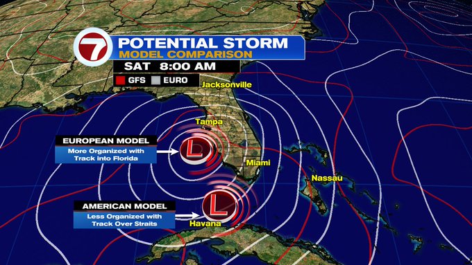
The consensus by the EURO & GFS is that whatever develops should be close to Florida by Saturday. The Euro tracks towards Central Florida with heavier rain for us, while the GFS places a system closer to home but with all the heavy rainfall over the Bahamas.
NWS Miami suggests some of the tropical downpours could starting impacting our area as early as Thursday night.
Even if the system remains weak, any additional rainfall over already soaked regions of South Florida from the Holiday weekend will surely lead to areas of street flooding.
As of Mid morning Wednesday, this has not been declared an Invest.
One more area of activity
For this the start of Hurricane season, NHC is also watching a second area for possible growth. A disturbance about 200 miles NE of the Central Bahamas, has disorganized showers. It is moving AWAY from land and has a low chance for development.
Seasonal Outlook
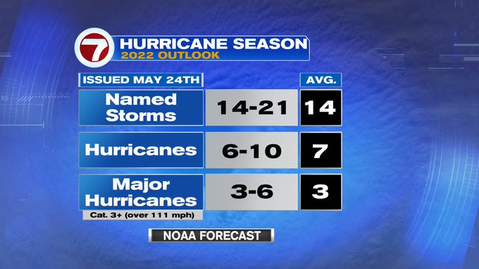
This is what NOAA is forecasting for 2022. Possibly 14 to 21 named systems, out of which 6 to 10 may spin up to become hurricanes, and out of that number maybe 3 to 6 could reach major hurricane status. Compare that to a typical season and it appears this season should be above average.
Hurricane Help!
WSVN's hurricane preparedness special, "Surviving a Storm". will help you navigate through the next 6 months. It is full of handy tips and crucial information to get you ready for whatever Mother Nature sends our way. It airs June 5th at 7 pm. Set your DVRs.
We'll keep monitoring.


No comments:
Post a Comment