The National Hurricane Center (NHC) is tracking or following Five areas in the Atlantic Basin. From powerful Hurricane Fiona, Tropical Storm Gaston, to three waves. One of which should be watched closely across the Caribbean.

- A tropical storm warning and hurricane watch is in place for Bermuda. They may have to deal with the system by the end of the week.
- Gaston would remain a worry only for the shipping lanes
- Of the three waves in the tropics, one is worthy of monitoring closely

The image above shows powerful Hurricane Fiona moving away from the Turks & Caicos. The unimpressive cloudiness by Venezuela is the tropical wave being watched. It doesn't look like much at the moment as shear or strong upper winds are keeping it from organizing. But NHC is giving it a 90% chance as of Wednesday morning for development.
Location: 10.2°N 59.0°W
Maximum Winds: 35 mph
Minimum Central Pressure: 1009 mb
Where may it organize?
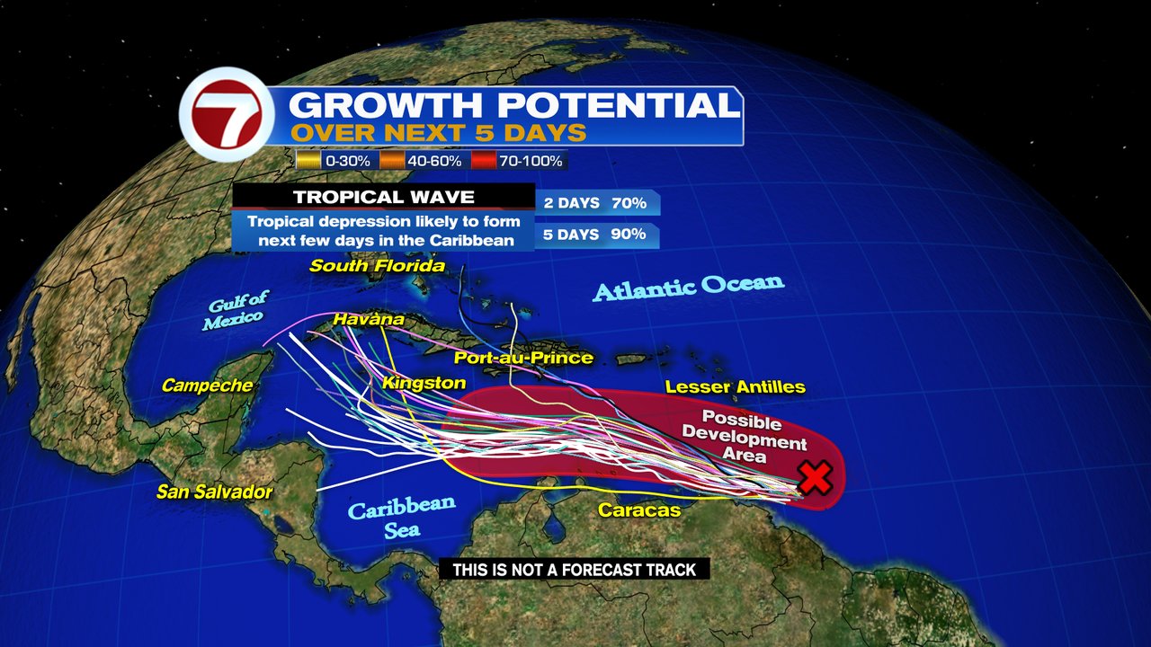
It may become a depression or a storm somewhere in the red shaded area over the next 5 days. Notice the models are indicating it could end up anywhere across the Caribbean through the weekend. All keep it away from Puerto Rico, Dominican Republic, and Leeward Islands. They were just struck by Fiona and do not need a repeat of that.
Impacts
From Trinidad and Tobago Weather Office
- Showers and isolated thunderstorms, at times heavy, are expected from Wednesday morning over oceanic waters and extending across Trinidad and Tobago. This activity is associated with an active tropical wave with potential for development over the next few days.
- Gusty winds in excess of 70km/hr can be expected along with rainfall accumulations of 75 – 125 mm. Street or flash flooding are likely in areas of heavy downpours.
- Impacts can include larger than normal waves in both open waters and in the Gulf of Paria. Tree branches and loose objects can be displaced during strong winds. Traffic disruptions are likely in flooded areas. Expect periods of lull between bursts of rainfall and thunderstorm activity.
From Jamaica Weather Office
Most guidance suggests that the disturbed weather approaching the Caribbean with potential for development will remain a strong tropical wave or tropical storm passing just south of Jamaica. It is, however, likely to become a threat so continue to monitor closely
Along the Coast, the possibility is there of some gusty winds and rain. That will increase as the wave moves further west.
How strong could it be?
 |
| Courtesy Tropical Tidbits.com |
Strength of a system is very difficult to forecast since there are so many variables. The graph above shows a handful of models trying to do just that. It appears that here too there is a wide spread since we really don't know the track yet. But the spread takes it as strong as a major hurricane in about 5-7 days.
For South Florida. No worries at the moment, but keep your eyes on it. Any system forecast to be near our area deserves to be watched.


No comments:
Post a Comment