A tropical wave East of the Lesser Antilles has a high chance for development according to the National Hurricane Center (NHC). As of Wednesday morning, the chances for organization have gone up to 70%.
This wide field satellite view shows a swirl just about in the middle of the screen, this is the wave being followed. It's also been deemed Invest 96L.
Close Up View
 |
| Courtesy Tropical Tid Bits |
The Invest is located roughly 800 miles East of the Lesser Antilles
Location: 16.4°N 49.1°WTop Winds: 34 mph
Minimum Central Pressure: 1009 mb or 29.80"
- Warm waters. This will provide the fuel it needs to grow
- Ample moisture: This will help in thunderstorm formation within the wave
- Shear. These are strong upper level winds that help cut down developing thunderstorms
Even if it doesn't turn into a depression or a storm, it will drop plenty of rain and cause gusty winds by the Leeward Islands towards the end of the week. The Virgin Islands & Puerto Rico should keep an eye on the wave. NWS office from Puerto says there is no immediate threat from this wave but some windy conditions and heavy rain is possible from Friday night into the weekend. In the long term, Dominican Republic, Haiti, & SE Bahamas should monitor.
Models
South Florida just needs to keep an eye out. It is still too early to determine where this system will ultimately end up.
Euro model
This model takes the wave (possible depression), westward into the Leeward Islands and thru Puerto Rico and Dom. Republic by September 18th.
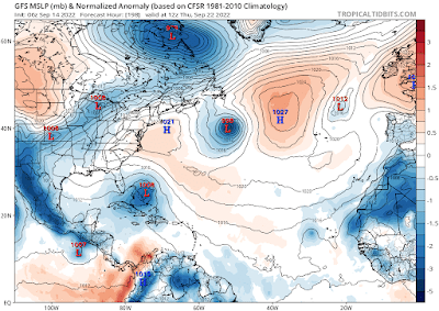
GFS Model
This model has a much longer run, going as far out as September 22nd. The run is a bit complicated, taking the system over the Hispaniola and almost falling apart. It then curves northward into the Bahamas and possibly staying east of the U.S.
CAUTION: Since there is no center of circulation and nothing has formed, these models are just giving us a guesstimate. Other models curve the system northward even before reaching the Lesser Antilles. Once a system organizes, then the models have something concrete to work with and can provide a more accurate forecast.
For South Florida: Even if the wave does not get any stronger, there is a chance we could see some tropical rain by early next week.
We'll be watching


No comments:
Post a Comment