Saturday, August 21, 2021

Hurricane Henri. Grace inland over Mexico

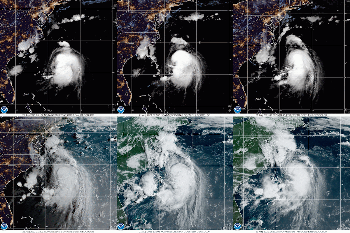
 The National Hurricane Center (NHC) says Henri is now a full category one, 75 mph hurricane.  They made the upgrade as of the 11 am, Saturday Advisory.


The satellite loop shows the transition between night and day. Growing from a compact swirl to a much larger and stronger system as of Saturday morning.

CONE:


It will continue to move towards the northeast section of the U.S.  This is what NHC has to say:

The latest run of the GFS
has shifted to the east, but overall the models are focused in on
landfall being between central Long Island and Rhode Island on
Sunday.  However, users are reminded to not focus on the center
itself, as impacts will extend well away from the center, especially
to the east.  

Impacts - Data from NHC. There are plenty:

STORM SURGE:  The combination of a dangerous storm surge and the
tide will cause normally dry areas near the coast to be flooded by
rising waters moving inland from the shoreline.  The water could
reach the following heights above ground somewhere in the indicated
areas if the peak surge occurs at the time of high tide...

Flushing, NY to Chatham, MA including Narragansett Bay, Buzzards
Bay, Vineyard Sound, and Nantucket Sound...3-5 ft
North shore of Long Island from Flushing to Montauk Point, NY
including Long Island Sound...3-5 ft
South shore of Long Island from Mastic Beach to Montauk Point,
NY...3-5 ft
Chatham, MA to Sagamore Beach, MA including Cape Cod Bay...2-4 ft
South shore of Long Island from East Rockaway Inlet to Mastic Beach,
NY...2-4 ft
Cape May, NJ to East Rockaway Inlet, NY...1-3 ft
Sagamore Beach, MA to Merrimack River including Massachusetts
Bay...1-3 ft

The deepest water will occur along the immediate coast in areas of
onshore winds, where the surge will be accompanied by large and
dangerous waves.  Surge-related flooding depends on the relative
timing of the surge and the tidal cycle, and can vary greatly over
short distances.  For information specific to your area, please see
products issued by your local National Weather Service forecast
office.

WIND:  Hurricane conditions are expected in the hurricane warning
area late tonight or on Sunday, with tropical storm conditions
expected by tonight.  Tropical storm conditions are expected in the 
tropical storm warning area late tonight and Sunday.

RAINFALL:  Henri is expected to produce rainfall amounts of 3 to 6
inches over portions of Long Island, New England, southeast New
York, and northern New Jersey Sunday into Monday, with isolated
maximum totals near 10 inches. Heavy rainfall from Henri may result
in considerable flash, urban, and small stream flooding, along with
the potential for widespread minor and isolated moderate river
flooding.

TORNADOES:  A tornado or two may occur Sunday over southern New
England.

SURF:  Swells generated by Henri should continue to affect Bermuda
during the next day or so.  Swells are expected to increase across
much of the east coast of the U.S. and Atlantic Canada today
and Sunday.  These swells could cause life-threatening surf and rip
current conditions.  Please consult products from your local
weather office.

Please remain vigilant. Power outages will occur long before the actual system moves on shore.  Get all your preps down today as quickly as possible.

Grace


After impacting the Mexican coastline as a category 3 with 125 mph, it has finally weakened to just below hurricane status. It is now a strong tropical storm still dumping plenty of rain. Flooding and mudslides will be widespread over the next few days.

Hoping for the next for our Mexican friends.

Sunday, August 15, 2021

Fred & Grace

 Not a 50's TV show, but a duo of storms in the Atlantic Basin. 


Fred back from the Dead

A hurricane Hunter mission Sunday morning, found that Fred soaked up some heat energy from the warm Gulf of Mexico and ramped back up to tropical storm status.  Folks across the Panhandle should prep for this arriving system. A Tropical Storm Watch is in place from The Alabama/Florida border east to Ochlockonee.

Cone


Grace


The disheveled looking system is just south of Puerto Rico. The island is under a Tropical storm Warning. Dominican Republic has a Flood alert in Place as well as a tropical storm warning. Haiti is under a tropical storm watch. We hope any impacts there will be minimal considering they were just hit with a very strong earthquake .

Cone


If nothing changes, the system should just brush the SE edge of Puerto Rico. Then, once again aiming for the tallest peak in all of the Caribbean in Dominican Republic. This encounter could weaken it considerably, much like it did with Fred. After that, the model consensus is that it will also follow Fred into the Gulf. Too early to take that to the bank as there are many variables ahead. 

Impacts from NHC Data

Over the northern Leeward Islands and Virgin Islands...3 to 6
inches. This rainfall may produce scattered areas of flash and urban
flooding.

Over Puerto Rico...3 to 6 inches with isolated maximum totals of 8
inches.  Heavy rainfall could lead to flash, urban and small stream
flooding and possible mudslides.

Over Haiti and the Dominican Republic...4 to 7 inches with isolated 
maximum totals of 10 inches. Heavy rainfall could lead to flash and 
urban flooding and possible mudslides from Monday into Tuesday.


Invest 96L


This swirl of clouds and rain about 200 miles NE of Bermuda has a 30% chance for development.  Most models keep it hovering near Bermuda in the short term, then it should go out to northern waters of the cold Atlantic.


We'll be watching

Saturday, August 14, 2021

2 Systems 2 Similar Paths

 The weekend starts with Fred as a Wave and a budding new storm to track. 


The Satellite view Saturday morning highlights. where the two systems are found. Fred over Central Cuba and New Tropical Storm Grace in the Central Atlantic. 

UPDATE: As of 11 am Saturday morning. Recon finds Fred down to a tropical wave. NHC says models suggest it may come back to life in the Gulf of Mexico and be a worry down the road for Mississippi and parts of the Panhandle.

Fred


Fred

It still has plenty of moisture with most of it being flung northward.  IF THAT DOES NOT FALL APART, The National Hurricane Center is forecasting:

Portions of Cuba...2 to 5 inches with isolated maximum totals of 8
inches. This rainfall may lead to scattered flash flooding.

Across the Bahamas...1 to 3 inches, with isolated maximum totals of
5 inches.

Through Monday, 3 to 5 inches of rain with local amounts of 8 inches
is anticipated across the Keys and southern Florida.  Across the
Florida Big Bend and Panhandle, 3 to 7 inches with isolated maximum
totals of 10 inches are expected.  Heavy rainfall could lead to
areal, urban, and small stream flooding impacts, and cause new minor
flooding across the western Florida Peninsula and exacerbate ongoing
minor to isolated moderate flooding in northern Florida.

Bottom line for South Florida. We may see rainbands move across the area from time to time with gusty winds. Rain is the biggest concern. Because of the possibility of heavy downpours, a Flood watch remains in place for South Florida.  Stay Alert.

Grace

Tropical Depression 7 was upgraded to Tropical Storm Grace. It is rapidly moving west and should be near the Leeward Islands  by Sunday. Watches and Warnings are in place for the Leeward Islands, Virgin Islands, and Puerto Rico. They could see gusty winds and heavy rain.


And of course, the forecast track has the system following Fred's footsteps. It may be near South Florida by next Thursday. I hope it turns out just like its predecessor and fall apart before it nears the region.

We'll be watching


Friday, August 13, 2021

Fred Eyes Keys

 Tropical Depression Fred is moving across north Cuba on track towards the Florida Keys.  Should be near the island chain Saturday midday. 


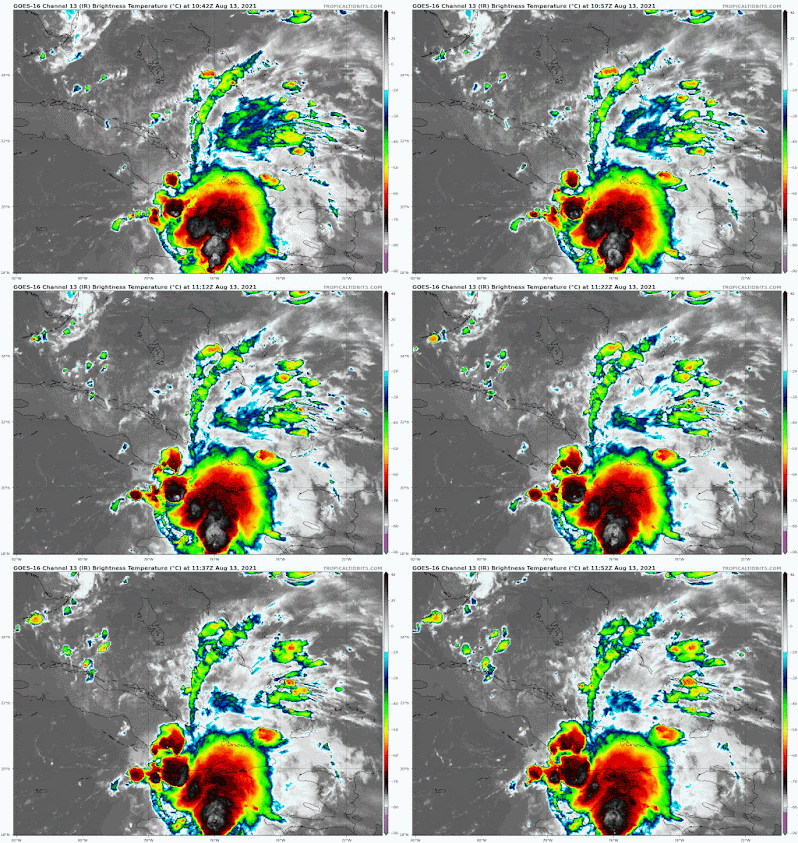
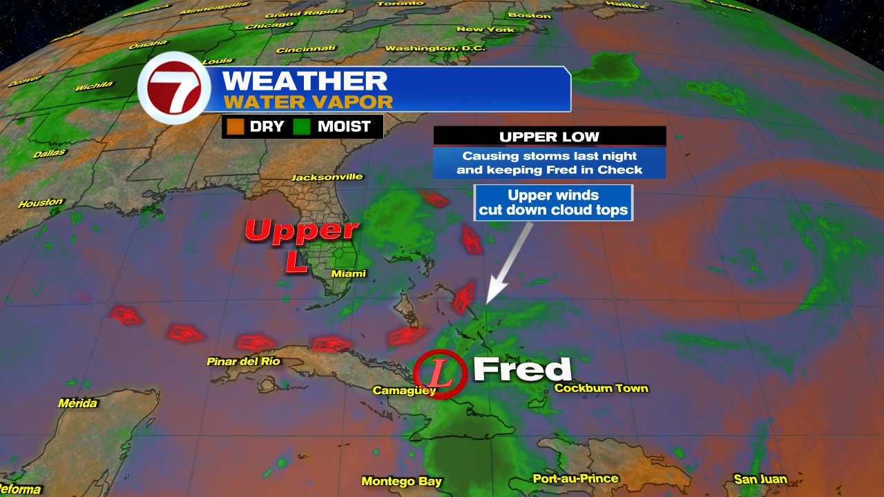
The satellite imagery shows a poorly organized depression. The center spin is almost across Central Cuba, while all the clouds and rain are on the Eastern end of the Island. One of the reasons why Fred is in bad shape is the rain over South Florida.


An upper low is parked over Florida dragging moisture our way and causing the strong storms. At the same time, the counter clockwise winds from the low, are shearing the cloud tops from Fred and disrupting its spin. This disruption however will relax later today allowing the system to gain some intensity. It could reach tropical storm status by Friday Afternoon.

Where is it going?

For the So Florida audience, Fred will track towards the Florida Keys. Possible arrival should be closer to midday Saturday. It will then move towards Florida's Panhandle.


A TROPICAL STORM WARNING has been issued for the island chain. This means wind speeds of 40 mph or better can be expected in the next 24 hours. 

Fred is not expected to be a wind event, but it is forecast to drop plenty of rain. 

A FLOOD WATCH- will go into place at 6 pm Friday for the Keys and at 8 pm for Miami Dade & Broward Counties.

Possible Impacts Info From NHC

Over Cuba and the eastern Bahamas...1 to 3 inches with isolated
maximum totals of 5 inches.

Across the western Bahamas...3 to 5 inches, with isolated maximum
totals of 8 inches.

From today into Monday, 3 to 7 inches of rain is anticipated across
the Keys, southern and central Florida north towards the Big Bend,
with isolated maximum totals of 10 inches. Heavy rainfall could lead
to areal, urban, and small stream flooding, and potentially worsen
ongoing minor to isolated moderate river flooding over northern
Florida.

LOCAL IMPACTS

  • Gusty winds to 40 + mph will be more prevalent throughout the Keys by Saturday midday. 
  • For Miami Dade & Broward Counties, we MAY get some of that in the form of strong rain bands coming in. These rain bands will be on & off.   There will be stretches of quiet weather and then a line moves through with torrential rainfall. 
  • This pattern will stay thru Saturday night. 
  • 4"-7" of rain is forecast 
  • The ground will not absorb any more rain and additional downpours will lead to flooding. 
  • STAY ALERT, if driving, you may not tell where the road ends and a canal begins.

As with any tropical system moving through or near our area, impacts can be felt far away from the cone. Aside from rainfall, isolated tornadoes will also be possible.

I'll be watching.


asdasdsa

Thursday, August 12, 2021

Weak Fred

 Tropical Depression Fred is having a rough time Thursday morning, but still hanging on.


This satellite view shows how disheveled it is. On the tip of Eastern Cuba is the center spin yet most of the dense clouds and rain are sitting over Haiti and Dominican Republic.  They will continue to see another wet day leading to more flooding. 

Fred is being impacted by some strong upper level winds that are helping to keep most of the rain away from the center. The main factor for its poor present state has been the high terrain of Haiti and Dominican Republic. It should run into more problems as it nears Cuba later on Thursday.

What is next?


The bulk of the models are trending more towards the Gulf of Mexico - Florida Panhandle as the end run but first it will travel over the Keys.  At this stage of the game, with Fred so anemic, the impacts for South Florida appear to be more rain than wind. CAUTION- Fred will travel through warm waters by Friday and it could regain strength back to tropical storm. Please stay alert.


The official forecast cone from NHC, includes the Keys and Mainland South Florida, except for most of Metro Broward and a small portion of NE Miami-Dade.  Please keep in mind that effects from a storm can be felt way outside the cone. Mother Nature does not recognize a line on a map.

Fred will get pushed northwest by high pressure in the Atlantic. On Thursday it will travel just north of Cuba and south of Southeastern Bahamas and the Turks and Caicos islands.  By Friday, Fred will be on the western edge of the high and will start turning northward. This will be a low process, and still unclear how quickly it will do so. But as shown on the spaghetti models,  most lean towards a westward track.

For the next 24 hours, the Cuban terrain should help keep it weak, but by Friday it's a different story.  The strong upper winds dogging Fred will relax and give it an opportunity to breath.  With plenty of warm water it should regain tropical storm status.

Possible Impacts Data from NHC

Across the Dominican Republic...3 to 5 inches, with isolated maximum
totals of 8 inches. Heavy rainfall this morning could lead to
flash, urban, and small stream flooding, along with possible
rapid river rises and the potential for mudslides.

Over Haiti, the Turks and Caicos, the eastern Bahamas, and Cuba...1
to 3 inches with isolated maximum totals of 5 inches.

Across the western Bahamas...3 to 5 inches, with isolated maximum
totals of 8 inches.

Beginning Friday into next week, heavy rainfall associated with Fred
will impact Florida and parts of the Southeast. Through Monday, 3 to
5 inches of rain is anticipated across the Keys and the southern
Florida Peninsula, with isolated maximum totals of 8 inches. Heavy
rainfall could lead to areal, urban, and small stream flooding,
along with possible rapid river rises.

WIND:  Tropical storm conditions, mainly in brief squalls, are
possible along the northern coast of Haiti and the southeastern
Bahamas this morning. Tropical storm conditions are possible in
Cuba beginning later today.

SURF:  Swells generated by Fred are expected to spread across
portions of the Bahamas and northern coast of Cuba during the next
couple of days.  These swells could reach the Florida Keys and
south Florida by early Saturday. Please consult products from your
local weather office for more details.

South Florida Possible Impacts - More a rain event than wind

Everything depends on how healthy Fred is by the time it reaches us. Even as a depression it could still cause plenty of rain.  The Keys, Miami-Dade and Broward counties could see amounts between 3" - 5". This will lead to flooding concerns.  It will be breezy from time to time with some gusty moments. Marine conditions will start to worsen by Friday.

Bottom Line:

If nothing changes with Fred, at worse it appears to be a tropical storm moving over the Keys. This means pockets of heavy rain with some wind around 40 mph. Lets keep our fingers crossed thats all it will be.

I'll be watching


Wednesday, August 11, 2021

Tropical Storm Fred

 The National Hurricane Center is tracking Tropical Storm Fred. Upgraded from Potential Storm 6, as of 11 pm Tuesday.


Wednesday morning: The system is not that healthy. It has not changed in intensity since late Tuesday night. It has some pockets of heavy rain, but it is looking less and less like a tropical system. IF IT Doesn't weaken before making landfall later Wednesday, it should provide moments of foul weather for parts of the Greater Antilles.

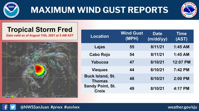
Even though Fred is a weak system, it has dropped rain across The Leewards, Virgin Islands & Puerto Rico but its also had some strong wind gusts.


CONE


The forecast track should remain mostly the same with the exception of minor fluctuations north and south. Intensity will also tick up or down depending on the impact of Pico Duarte on Fred. This is the highest terrain in the Caribbean. It can shred the system or deflect it in another direction.

IMPACTS

Fred should move onshore Dominican Republic Wednesday. The main impact will be in the form of rounds of rain. 

These are the local storm advisories for Dominican Republic. The highest alert in red.


If Fred, survives its brush with land and Pico Duarte at over 10 thousand feet tall, it could pass by the SE Bahamas, Turks & Caicos by Thursday. It would then travel just north of the Cuban Coast & south of the Central Bahamas on Friday. 

Rain Forecasts

If models are correct, this systems should not be a wind event, more a rain event.

Puerto Rico & Dominican Republic: 2' - 4" of rain with some spots as much as 6". This will lead to the threat flooding, land and mudslides. Flood Alert remains in place for Dominican Republic. 

Haiti, Turks & Caicos, SE Bahamas, & Eastern Cuba: 1" - 3" with isolated spots up to 5". No Flood Advisories have been issued yet.

South Florida: MAY see some gusty winds and rain starting Friday and into the weekend. Starting by the Keys and moving northward. Still too early to be precise. Many things can happen. The system may get disrupted by Dom. Republic to the point where it may fall apart.  On the other hand, if the center emerges relatively undisrupted over the warm waters north of Cuba, it may be stronger.  Keep checking every so often. 

Bottom Line: At the moment this storm appears disheveled. If it can retain its identity after its encounter with Dominican Republic, it could arrive as a tropical storm in So. FL by the end of the week. How intense it may be is still uncertain. There are many roadblocks in its path for it to intensify greatly, but it will be traveling over warm waters that could allow it enough fuel for growth. I wish I had a more definitive outlook, but there are too many variables. I suggest keep monitoring and be ready just in case.

We'll be watching 

Tuesday, August 10, 2021

Potential Storm #6

Tuesday morning has us waiting on Potential Storm 6. Will it stay as a weak system or intensify into Tropical Storm Fred. 


Satellite imagery reveals a better looking system this morning, trying to develop your typical hurricane shape but it has yet to close off its center. Until then, no tropical storm. A recon mission is underway to determine if that has happened. 

The system continues to drop plenty of rain across the islands, and has the potential for flooding until it moves out of the region.


Heavy rain has impacted parts of the Leeward Islands and will continue to spread into the Caribbean later on Tuesday. This will impact the Greater Antilles over the next 24 to 48 hours.

Forecast

The cone suggests it may stack over most of the land masses in the Caribbean. We will need to watch where the center travels. If it slides over water, it could get a little more stronger. If it tracks directly on land, then a weaker storm can be forecast. This will change as the storms spins and interacts with the terrain. An updated cone is available every 3 hours.

If the center of the system tracks directly over Dominican Republic, it will run into the largest peak in all of the Caribbean, Pico Duarte standing at over 10 feet high. This could shred the system. It could also push it in a different direction. 


Impacts
Data from NHC
RRAINFALL: The potential tropical cyclone is expected to produce the
following rainfall amounts:

Over the Leeward Islands, Virgin Islands, and Puerto Rico...2 to 4
inches, with isolated amounts of 6 inches.  Heavy rainfall could
lead to flash, urban, and small stream flooding and potential
mudslides across the U.S. Virgin Islands and Puerto Rico.

Over the northern Windward Islands...1 to 3 inches.

Over the Dominican Republic...3 to 6 inches.

WIND:  Tropical storm conditions are possible within the watch area
in the Lesser Antilles for the next few hours.  Tropical storm
conditions are expected in the warning areas in the U.S. Virgin
Islands and Puerto Rico later today, and in the Dominican Republic
by early Wednesday.  Tropical storm conditions are possible
elsewhere along the northern coasts of the Dominican Republic,
northern Haiti, the Turks and Caicos, and the southeastern Bahamas
beginning late Wednesday.

SURF:  Swells generated by the disturbance are affecting portions of
the Leeward Islands.  These swells are expected to spread across the
U.S. Virgin Islands and Puerto Rico today and across portions of
Hispaniola on Wednesday, and they could cause life-threatening surf
and rip current conditions.  Please consult products from your local
weather office.


South Florida

The system should track towards our area and be near us sometime by the end of the week. There are too many variables to determine specific impacts. If the storm manages to keep its center over warm water, it could be stronger by the time it arrives. If it stays over land, it should help keep it weak.  If the center also makes a direct landfall over Dominican Republic, it should run into Pico Duarte, the highest terrain all of the Caribbean. This could shred it apart, or even deviate its track.  It is traveling over hot waters which can provide it plenty of fuel for growth. There is also very little shear in its path.

We are a month away from the peak of hurricane season. Lets be alert and ready if it indeed comes calling.


We'll keep you updated.

Subtropical Storm Nicole

We begin the work week with the prospect of a tropical system impacting the East Coast of Florida this week. This is Subtropical Storm Nicol...