Tuesday, September 20, 2022

Fiona, a new Depression, and a Wave to Monitor

 The First Major Hurricane of 2022

Major Hurricane Category 3 Fiona, is leaving flooding and destruction in its wake. Presently battering the Turks & Caicos and aiming for Bermuda possibly even stronger upon arrival. 

Satellite Loop


Over the early morning hours of Tuesday, USAF hurricane hunters detected a much lower pressure reading with stronger winds. It is now the first Major Storm of the season.

If there is one thing that could keep this monster from gaining more strength is the impact Shear, or strong upper level winds, is having on the western side of Fiona. It is preventing outflow from the storm. 

Imagine an engine with an exhaust pipe. A hurricane is a tropical engine and its exhaust pipe is wind rushing to the very top of the hurricane and exiting.  Well the shear is preventing that from happening, keeping Fiona from firing on all cylinders, and yet here we are with a cat three on our hands.

What next for Fiona?


It will track NW for a day or so and then make a northeasterly turn and trek towards Bermuda. 

In the meantime:

  • Turks & Caicos (Located at the extreme Southeast stretch of the Bahamas) will get hit hard by this major system throughout the day. 
  • Strong gusty downpours will remain on and off across Eastern Dominican Republic 
  • More pockets of heavy rain will hamper clean up efforts in Puerto Rico. Additional street flooding is possible 
  • Bermuda should be prepping just in case Fiona does not weaken 

For the latest on storm forecasting, clean up, donations, and storm updates please follow us on-air and on-line for the latest.

Tropical Wave to Watch
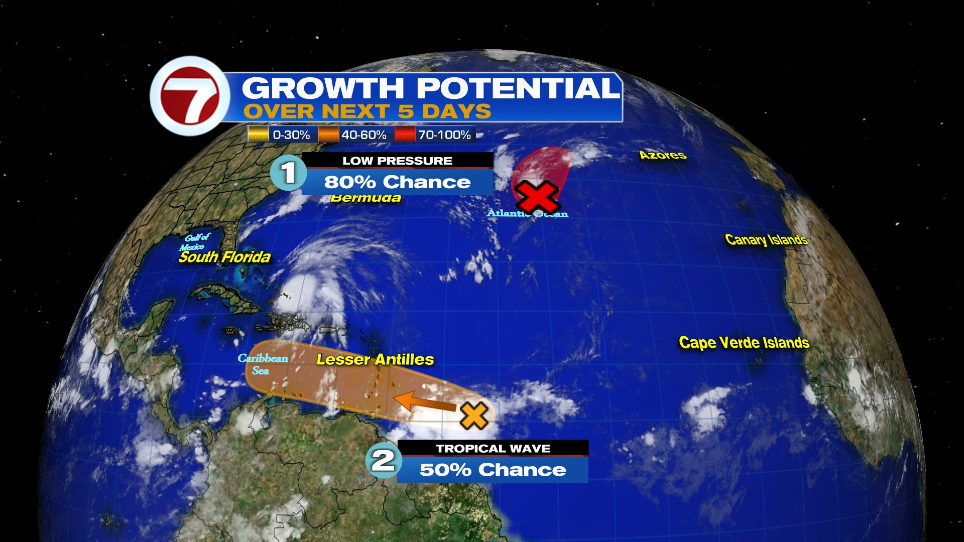

The National Hurricane Center (NHC) is actually monitoring two ares for development. The one in red was upgraded to Depression 8, it should just be a worry for the shipping lanes. Meanwhile the one in orange will be a concern throughout the Caribbean.


This robust wave is sitting a couple of hundred miles East of the Windward Islands. It has plenty of thunderstorm activity and may develop into a depression or storm in the area highlighted.  

This is now Invest98L

Located: 10.3N, 53.0W. The pressure is holding at 1011 mb with winds around 30 mph.


Extremely early models suggest a track into the Caribbean or Gulf of Mexico. These are just guesstimates but they give us a general idea of the area the system may be down the road. They will change plenty in the days ahead.  For my Caribbean friends, please monitor the wave carefully so you have time to prepare.  For South Florida. Keep your eyes on it.  This is another example that Hurricane season is still here and getting very active.


We'll keep watching


Friday, September 16, 2022

Tropical Storm Fiona

Tropical Storm Fiona is a bit weaker Friday.  The winds are down from 60 mph Thursday night to 50 mph now. The National Hurricane Center (NHC), says that while the system is wobbling southwestward, its general motion is to the west.


Health Check

Once you get to the daytime imagery in the loop, you'll see the center spin of the system. We can diagnose that the western side is almost cloud free with no rain, while all the cloudiness and storms are relegated to the eastern side.  This means it's battling shear (strong upper level winds) along with dry air. As long as this is around, Fiona will remain a compromised storm. This is good news for the Leeward Islands. They should not get a strong wind storm, but the rain may be a different story.

Where is it going?


High pressure in the Atlantic will continue push Fiona to the West in the short term. After it moves over the Leeward Islands, it may then trek near Puerto Rico, followed by an impact over the Dominican Republic and Haiti.

Once it reaches the western periphery of the high it will turn north. The question will be, "when will it happen?" An early turn means it may impact the Central Bahamas and then Bermuda. A later turn and the NW Bahamas and Florida could be next.

Keep in mind that the cone shows where the center of circulation could be at any given time. It can be situated on the west side of the cone as well as the eastern side.

Intensity Forecast

If it impacts any land masses, such as Dominican Republic, it may be an even weaker system as it moves into the Atlantic waters. This is because of Pico Duarte , the highest terrain in all the Caribbean. This should mess with its circulation and keep it from getting stronger at the very least.

Once in the Atlantic, it will move over warm waters and have a chance to intensify.

Impacts

  • Leeward Islands & Northern Windward: By this afternoon and early evening Winds will pick up to tropical storm strength. Rainfall: 3" - 6".  
  • U.S. & British Virgin Islands: Deteriorating conditions by Saturday with rainfall totals of 4" - 6" 
  • Puerto Rico: Could see tropical storm force winds by late Saturday with building rain bands. Total accumulations will range between 4" - 8", with some local spots as high as 12". This will lead to flooding, land and mudslides. A storm surge will accompany the storm 
  • Dominican Republic and Haiti: Depending on where it makes the turn. Right now NHC has it impacting the east coast of Dominican Republic. Tropical storm force winds are forecast with rain totals of 6" - 10" with localized areas up to 16". The threat for flooding will be present. Haiti will also see some rain and should monitor the path of the storm closely.  Advisories may be initialized for you later this Friday
  • Turks & Caicos: Very dependent on when Fiona turns Northward. You may get some gusty winds with a rain potential of 4" - 8"

South Florida and the Bahamas

For the time being all we can do is monitor the progress of Fiona. Many things can happen. 

  • The shear may keep knocking it down. 
  • The impact with any of the islands could weaken it further. 
  • If the high moves east it could exit the Caribbean early and head into the Atlantic with a possible trek over the SE or Central Bahamas. 
  • But as we all know, once in the Atlantic it will move over warm waters and that could help make it stronger.

A better solution on the forecast will probably come by the weekend for this area. This is a good reminder that we are in the busiest month of hurricane season and we should be mindful of any system forecast to be close to the region.

We'll be watching

Wednesday, September 14, 2022

Tropical Wave to Watch

 A tropical wave East of the Lesser Antilles has a high chance for development according to the National Hurricane Center (NHC). As of Wednesday morning, the chances for organization have gone up to 70%.


This wide field satellite view shows a swirl just about in the middle of the screen, this is the wave being followed. It's also been deemed Invest 96L. 

Close Up View

Courtesy Tropical Tid Bits

The Invest is located roughly 800 miles East of the Lesser Antilles

Location: 16.4°N 49.1°W 
Top Winds: 34 mph
Minimum Central Pressure: 1009 mb or 29.80"

The showers and thunderstorms within the wave have not diminished as of Wednesday morning. On the satellite loop above you can see the spin coming together. The reds and oranges represent where the heaviest rain can be found. The west side of the system remains cloud free. Once it closes it will be a sure sign of organization.


If it is going to organize, it will do so inside highlighted area.

Working for the wave:
  • Warm waters. This will provide the fuel it needs to grow
  • Ample moisture: This will help in thunderstorm formation within the wave

Working against the wave:
  • Shear. These are strong upper level winds that help cut down developing thunderstorms

Where is it headed?

Even if it doesn't turn into a depression or a storm, it will drop plenty of rain and cause gusty winds by the Leeward Islands towards the end of the week.  The Virgin Islands & Puerto Rico should keep an eye on the wave. NWS office from Puerto says there is no immediate threat from this wave but some windy conditions and heavy rain is possible from Friday night into the weekend. In the long term, Dominican Republic, Haiti, & SE Bahamas should monitor.

Models

South Florida just needs to keep an eye out. It is still too early to determine where this system will ultimately end up. 

Euro model


This model takes the wave (possible depression), westward into the Leeward Islands and thru Puerto Rico and Dom. Republic by September 18th.

GFS Model


This model has a much longer run, going as far out as September 22nd.  The run is a bit complicated, taking the system over the Hispaniola and almost falling apart. It then curves northward into the Bahamas and possibly staying east of the U.S.  

CAUTION: Since there is no center of circulation and nothing has formed, these models are just giving us a guesstimate. Other models curve the system northward even before reaching the Lesser Antilles. Once a system organizes, then the models have something concrete to work with and can provide a more accurate forecast.

For South Florida: Even if the wave does not get any stronger, there is a chance we could see some tropical rain by early next week.


We'll be watching


Thursday, September 8, 2022

Bookend Hurricanes

The U.S is in between two hurricanes. One may cause choppy seas to the U.S., while the other could drop heavy rain across parts of California.


This is the Thursday morning world Satellite loop. South America is to the bottom of the page and the U.S above. There are two cloud swirls on either side of the country. On the east is soon to be very powerful hurricane Earl, the other is hurricane Kay, near Baja California .

Hurricane Earl


Satellite imagery over the storm shows the center of circulation with nice rain bands. It's moving over warm waters and is forecast to become a major hurricane later today.  Fortunately it should remain over open waters bypassing Bermuda. BUT they are not totally out of the woods. If the system makes any little jog west, they may get more of its fury. For the moment, Bermuda is under a Hurricane Watch. Some gusty winds are possible today.

The East Coast of the U.S may see some indirect impacts: This is from NHC.

Surf: Swell generated by Earl are building near Bermuda and are expected to reach the U.S East Coast later today/tonight.

These swell are likely to cause life-threatening surf and rip current conditions thru the weekend. 

South Florida will not see impacts from the system.


Hurricane Kay


The Satellite imagery reveals a rather large Cat 1 hurricane with heavy rain and tropical storm force winds impacting Baja California. The system  will hug the coast for the next several days.

U.S. Impacts


Southern California: 2-4 inches of rain with 6" in spots Large Swells will impact the California Coast causing rip currents Southwest Arizona: 1-2 inches with 3 inches maximumThese totals may lead to flash floods and mudslides


Monday, August 8, 2022

Long Tropical Slumber may be Over

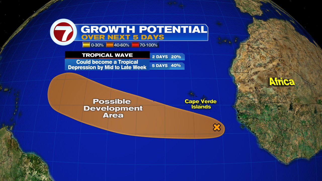
This week the National Hurricane Center (NHC) is eyeing a wave by the Eastern Atlantic with a chance for development. It emerged off the Coast of Africa over the weekend and is moving WNW 15 - 20 mph.


On Satellite imagery you can see the area being monitored with deep reds and oranges right next to the African Coast.  It now appears the Tropics are waking up. This may signal the start of Cape Verde Season in which waves coming off Africa venture near the islands and then head into the Atlantic with better chances for growth.


This close-up infrared satellite loop shows where you can find the heaviest downpours by the darkest colors. The wave is looking healthier this morning with storms developing  with a hint of a spin. NHC will be watching if more thunderstorms develop within the wave, as a sign of organization.

Chances for Development


As of Monday morning the wave has a 40% chance for development. It could grow into a depression by the middle to end of this week. If it organizes it will do so in the area highlighted in orange.

Invest 97L

Also NEW, NHC has deemed this wave Invest 97 L. "Invest" for an area they would like to "INVEST"-igate further, "97" is a tracking number, and "L" is for the Atlantic Basin.  This allows them to initiate some very early model runs.


Keep in mind these are guesstimates since nothing has formed. Strong Upper Winds (Shear) which could keep the system from organizing, are barely present. There's still some Saharan Dust to contend with, and Sea Surface temps are not that warm there. A NOAA High altitude mission has been scheduled for Tuesday.

Models

European


This run does not know what to make of Invest 97 L and keeps it out in the East/Central Atlantic. It suggests a very strong dome of high pressure to the north will keep the wave stuck in the region with a slow drift westward.  Will have to wait and see what later runs suggest.

GFS


This is a more aggressive outlook with a possible depression/storm developing and moving north of the Leeward Islands. 

This feature is very far away from any land areas and we'll have plenty of time to watch. We are now going into the most active part of the season as we progress thru the rest of August and September. Its a good reminder to make sure you are ready in case Mother Nature throws us a curveball.

A Quiet Streak


South Florida is experiencing rather tranquil conditions with the last system reported over a month ago.

We'll be Watching


Tuesday, June 28, 2022

Watching thee areas

It's very crowded in the Tropics this Tuesday with two disturbances being followed for possible development and one potential storm.


To the right of the image above, we see Africa with yet another wave coming off the Coast. In the center of the picture we find what MAY become Tropical Storm Bonnie, and way up in the upper left hand corner is a small disturbance poised to dump plenty of rain across Texas.

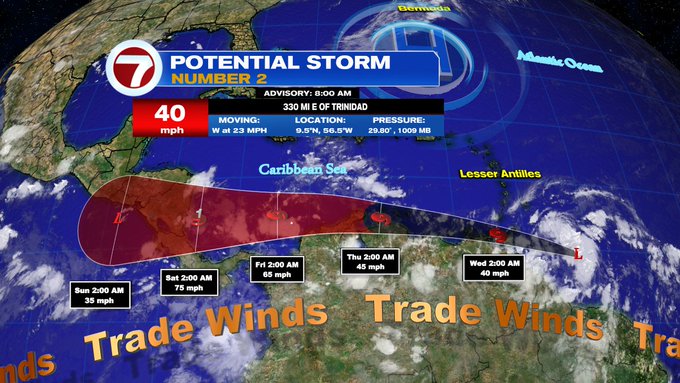
Potential Storm #2


As of Tuesday morning, this system was moving west rather quickly.  This is keeping it from forming a well closed center of circulation and even further thunderstorms.


Sunrise over the Central Atlantic shows some bubbling cloud tops correlating with thunderstorm activity. It will be interesting if the system can overcome many hurdles today. For the moment, the low level spin is moving faster than the higher part of the system. This will keep it struggling for awhile. 

There's also the forecast track. Will the center stay over water and gather more energy from the warm waters or will it move onshore Venezuela and get cut off from its fuel source.

Where is it going?
The forecast cone shown previously, keeps the center hugging the South American Coastline. Even if it doesn't become Bonnie right away, it will dump plenty of rain across the region. From Trinidad & Tobago, over Venezuela & Colombia.  

Eventually, the models do take up to hurricane status just before moving onshore Central America. They suggest warmer waters and low shear in the SW Caribbean Sea could intensify the system.

Impacts (From NHC)

RAINFALL: The Potential Tropical Cyclone is expected to 
produce heavy rain across the southern Windward Islands 
and the northeastern coast of Venezuela starting tonight 
into Wednesday.  The following storm total rainfall amounts 
are expected:

Islands from Guadeloupe to St. Lucia: 1 to 3 inches.

St. Vincent, the Grenadines, and Barbados: 3 to 5 inches.

Grenada, Trinidad and Tobago, and northeastern Venezuela: 
4 to 6 inches.

WIND:  Tropical storm conditions are expected in the warning 
area in the southern Windward Islands tonight. Tropical 
storm  conditions are possible in the watch area along the 
northeastern coast of Venezuela

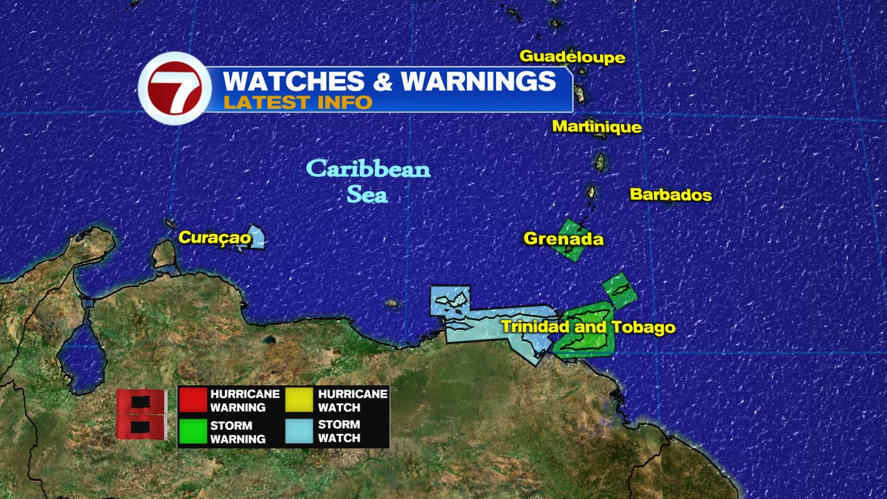
Watches and Warnings

The following areas are under Tropical Storm Watches and Warnings

What is a Potential Storm?

This is a designation NHC uses to allow watches and warnings to be issued, before the low can become an actual Tropical Storm. It gives folks in its path more time to get ready instead of waiting until the storm is on them to do so.

Two other areas being watched 

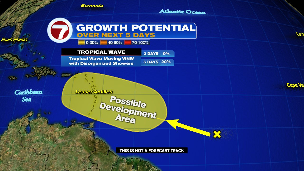
NHC is monitoring a wave behind Potential Storm #2 with a 20% chance for organization in highlighted area, while another feature is being monitored in the Gulf  with a 30% chance for growth. Both are capable of heavy rain.

In the Atlantic


In the Gulf of Mexico


We'll be watching 

Sunday, June 26, 2022

Tropical Activity in the Gulf & Atlantic Ocean

 UPDATED: The new week starts with the National Hurricane Center (NHC) monitoring two areas for development in the Central Tropical Atlantic and a third in the Gulf of Mexico.


We start with the first Atlantic Wave

This satellite view shows imagery over the Atlantic.  The area of clouds we are focusing on is roughly 900 miles E/SE of the Windward Islands. A NOAA high altitude recon mission is set for today with hurricane hunters on standby for Tuesday. 

The wave maintained its form over the weekend without getting stronger,  but now conditions appear more favorable for further development.  It's moving West 15 - 20 mph. 


NHC is giving this wave a 90% chance that it could become a depression/storm anywhere inside the red highlight over a period of 5 days. If it reaches tropical storm status it will be named "Bonnie". Even without organization it could drop plenty of rain across the Windward Islands, Trinidad & Tobago, as well as Northern Venezuela. Advisories could be issued for them as early as today.

Second area of concern in Atlantic

This is another wave just behind the first. It is moving WNW at 15 mph. This one could be more of a headache as it appears to be tracking farther north than the previous. 


NHC suggests it has a 20% chance for organization inside the yellow area over a 5 day period.  The Lesser Antilles could see pockets of heavy rain in the days ahead.

Activity in the Gulf


The area of clouds sitting mostly over Louisiana, Mississippi, & Alabama is a disturbance that has a low chance for intensification. 

NHC says it will drift west and possibly organize by the Texas Coastline. They give this possibility a 20% chance over 5 days.  Even if it doesn't come together it will be capable of heavy rain.


We'll be watching


Subtropical Storm Nicole

We begin the work week with the prospect of a tropical system impacting the East Coast of Florida this week. This is Subtropical Storm Nicol...